Monday, July 26, 2010

Haines Junction to Tok and Fairbanks Alaska

Beauty of the Canadian Rockies at Haines Junction, Yukon Territory


It's been a week since I left Haines Junction, Yukon Territory for Alaska, but you're just reading of that fact on yesterday's blog.

I am now in Fairbanks where I've been for the last five days.  From Haines Junction I traveled northwest to Beaver Creek the western most community in Canada, near the Alaskan border and then went west to Tok, Alaska.

The road from Dawson City, Yukon to Tok, Alaska (closed as result of the floods) was opened the day after I arrived in Tok, but I understand that it is still slow going and definitely sub-standard conditions.

Kluane Lake, Yukon Territoty
From Haines Junction to Tok, Alaska continued to be a thing of beauty.  As it past the region of Kuane Lake the scenery took on a new and different, but still beautiful look.

After a day and a half in Tok, I departed for Fairbanks having remained in Tok only in an effort to avoid the threats of rain.

The road to Fairbanks was excellent, although, devoid of any scenic beauty.  At least the weather had warmed up considerably and I arrived in a dry condition.

Surprisingly Fairbanks actually receives very little rainfall; with just 11 inches annually it almost qualifies for desert classification (by definition a desert receives less than 10 inches of annual precipitation).

Kluane Lake, Yukon Territoty
Fairbanks has all of the amenities of a big city without the typical big city congestion.  With a 2008 estimated city population of 35,132 that swells to a metropolitan area of 97,000.  Fairbanks also lays claim to the widest temperature spread of any city in the world, from -66 degrees to 99 degrees Fahrenheit.

This past week Fairbanks has been celebrating its Annual Golden Days Celebration which is accompanied by the World Eskimo and Indian Olympics (complete with events such as the ear pull, blanket toss and two legged kick) and included a Saturday morning parade.
______________________________________________________________

Many years ago the popular saying of the day was various versions of - "I just need time to find myself".  It seemed to be most commonly repeated by the young restless souls who were struggling to find their place in the world.

Kluane Lake, Yukon Territoty
It was never a comment for which I ever felt a kinship; I thought it was too much of an escape from the realities of life.  I always believed (rightly or wrongly) that I knew what I wanted to be and where I was going.

However, today I find myself harking back to that yesteryear and finding a new reality, a reality with which I am still not all that comfortable.

Like it or not I am a bit of a lost sole; not in a sad or lonely way, but in a sense that I am searching for new meaning and purpose in my life.

Strangely, and somewhat incongruent with what I've just said - I love my wandering ways!  I just feel a need to bring a meaning or purpose, into all that I do.

Blanket Toss at World Eskimo-Indian Olympics
No matter how much we tell ourselves that, "I don't care what other people think;" the reality, for most of us is - that we really do care!  We need that moral support (or at least we need to "feel" that it exists) in order to carry forth with our daily lives.  Perhaps, I should not be so bold as to presume what "others" think or believe; when I say "we" it is used only in the context that I believe that their are others of you out there, with whom I share that common bond.

And so I continue my quest to "find myself," - but I don't like it!

I would like to travel north to Prudhoe Bay, but that is a five hundred mile trek on mostly gravel roads with miles between gas stops.  I don't know how far I could go on my Harley; most motorcycle riders who go that way are riding BMW's, Kawasaki's or Yamaha's with tires designed to handle the gravel and mud terrain.

Golden Days Parade - Fairbanks
Maybe if I got fitted with pair of "knobby tires" on my Harley, in order to handle the gravel and mud, it would an attainable goal.  Even then, however, I would need a bit of luck; but then, - ...luck is very thin wire between survival and disaster and not many people can keep their balance on it."  ("Author's Note by Hunter S. Thompson" - "Fear and Loathing in America").

It would probably be stupid, absurd or even a little insane just to try the trip on a Harley - Got to Go!
                        
                          _________________________

The above was completed yesterday (7/25/10) and deliberately held for posting today; but now, today is here and I have received more information - both good and bad.

Some say that the belt drive won't handle the abuse of the Dalton Highway, others say that there are a lot of Harleys that make the trip, all say - it's a beautiful trip.

It's 499 miles from Fairbanks to Prudhoe Bay with the last half being all gravel; I'm heading north and at least as far as Coldfoot (which I've been told is all paved and the approximate halfway point).

Sunday, July 25, 2010

Haines Junction Yukon Territory - At Last

Mike Howard and Sockeye Salmon
Still determined to make to Haines Junction, I nonetheless, stopped in the Chilkat Bald Eagle Preserve to check with a fisherman there.

Mike Howard, originally from Palm Springs, California, has been living Alaska for twelve years.  Gregarious and likeable, with a shock of white hair and beard, he characterizes himself as a subsistence fisherman (which has a legal precedence in Alaska).  By law he can gillnet up to a limited number of fish (depending on the breed) for his or his families own consumption.

On the day I was there, he was busy cleaning his catch of sockeye salmon (which he had already gifted to a friend).

Three Photos From Klukwan Alaska
He had a small contingency of friends who kept dropping by (possibly because he apparently made it a practice to give away part of his catch).

Proceeding on my way to Haines Junction, I passed a sign indicating a left turn to Porcupine.  It was still early in the day and Haines Junction was only about a three hour ride and the road towards Porcupine was paved.  And so, I reasoned - why not check it out?

The road to Porcupine crossed over the Chilkat River where a sign at the edge of the roadway proclaimed that this was the historic Dalton Trail, and that nine miles up the road was Porcupine; the site of the Porcupine Mine discovery.

I continued, hoping to find an old Ghost Town and the Porcupine Mine.  Less than a quarter of mile later, the paved road turned to gravel.  Although, not particularly "motorcycle friendly" it was firm gravel with bumps and pot holes, but no sand (I could handle the bumps and pot holes).

Traveling slowly and with care, there were signs of ongoing logging activity, but no mining was evident until at the 8 1/2 mile point, where the road forked and sign was posted "Big Nugget Mine."  A gate potentially blocked the road, but the gate was open, and so I continued on, assuming that since there were no signs warning - "No Trespassing" - it was safe to proceed.

After taking pictures of the Big Nugget mining office, I turned around and left the area - still fearing that I was trespassing.  I never found the old settlement of Porcupine which was said to have had a population of about 500 during the peak mining years.

It was already getting late, but I was having too much fun just exploring; and so, I decided to continue my foolishness.

Turning down one the few side roads, I found the peaceful looking "Chilkat Valley Farm;" a small idyllic pastoral setting neatly tucked into the valley - just "oozing" peace and tranquility.  It was so neatly (or perhaps even, lovingly) maintained homestead that it was almost impossible not to feel comforted by the setting.  I had to assume from the setting that it was a totally organic farm (but there was nothing there to confirm my supposition).

After returning the highway I came to a sign indicating a left turn to Klukwan; since I was on a roll - why not?

I found Klukwan discomforting in a way; in spite of the junk cars and junk "everything" discarded with an "I don't care attitude" there were remnants of a past that showed great pride in what once were architectural homes of character, with beautiful facades that are, even today, impossible to ignore.

Three Photos - on the Road to Haines Junction 
It was sad to see these homes still striving to maintain the dignity that they once held, a dignity that was now lost forever; and it was impossible for me not wonder how the residents of Klukwan could leave buildings and homes, such as these, to decay beyond repair before there very eyes - how sad!

In spite of the "side ventures" the third effort to make to Haines Junction was a success, but it took much longer to cover the 160 miles than one would suspect (about 7 hours). It was not only the side ventures, but the trip itself was one of fantastic beauty; made more unique by the forested mountains and grassy mountainsides.

Friday, July 23, 2010

Haines Alaska

Ferry From Skagway to Haines

Everything worked as hoped; it was indeed possible to take the ferry by motorcycle and go either to Juneau or Haines, Alaska.  Juneau (while it would be nice to see the capital city) would still leave me landlocked; there are no roads in or out of Juneau.

At the rate of $100 each way, Juneau was never a viable option, and in the morning I left for Haines.

The ferry ride was somewhat disappointing, the anticipated souring glaciers were no where to be seen.

In contrast, Haines is a beautiful city; or more accurately, it is a beautiful setting.

Looking across the bay my eyes were drawn to the site of the large homes that adorned the mountainside.  As picturesque as the view was, however, the clouds so thoroughly obscured the mountains that, it was not until later when I saw that very image displayed frequently around Haines and on brochures promoting the area, when I fully realized I was missing much of what must be a truly breathtaking sight - the souring mountain peaks, as a backdrop to Fort Seward, that make the image a favorite of artists and photographers alike.
  
I did not realize at the time that I looking at the site of the military base of old Fort Seward, but I knew that the site would be my first stop.

Even though, as captivated as I was by the sight of the large homes across the bay of open water
I would never see that entire image in its full glory.  Unrelenting, the clouds never broke.

Today the large buildings that once served as officer quarters, administrative headquarters, medical centers and the like, have now been converted into hotels and condominiums.  Further below them and across the old parade and exercise field stands the one remaining (of the original two) huge 2 1/2 story barracks building.  Too costly to repair, it stands as a sadly decaying hulk.

The setting was perfect, my campsite was owned by the Halsingland Hotel (one of the hotels converted from the old officers quarters); and was low priced, had WiFi, showers, laundry and a bar/restaurant - all of the amenities of home!

Smaller and lacking the hoards of tourists that highlight Skagway, the main claim to fame for Haines is the Chilkat Bald Eagle Preserve; the site of the largest collection of bald eagles in the world.

Fort Seward From Across the Bay
Unfortunately the season for seeing eagles in mass is during the months of October and November.  I was told there are thousands of the big birds at that time who are not only prominently visible, but easily approachable to within a few feet.  The reason is that during this time, the eagles in committed feeding frenzy; basically the "lid is off the cookie jar" in the form of dying salmon which are gobbled up by the eagles.

The next day, having completed my tour of Fort Seward, I rode out to Chilkat State Park hoping to catch sight of the black bears (a mother and two cubs) that had been reported to be in the area.

The fishermen were already wading the in the waters of the Chilkat River (hoping the hook one of the early salmons just beginning their annual run up the river); but no bears were seen.  I would have to wait until two days later (when on the ride from Haines to Haines Junction, British Columbia) to catch sight a seemingly friendly bear, caught idly munching at the roadside.

Almost too "seemingly friendly;" unconcerned by my attention, the temptation was to slowly approach closer to get a better photograph.  I had to caution myself, remembering that "this after all a wild black bear" that if threatened by my advance would perhaps - Well, I just didn't push it!

The  Barracks at Ford Seward
However, I'm getting ahead of myself.  After returning from the state park, I went over to the hotel to address their WiFi.  While there working on my computer, I met the congenial Elize Winby Wall who was also working on here computer.
                
We conversed and I learned that she was a casualty of computer downsizing, we discussed are seemingly similar situations - both of us retired, but neither if us by choice!

She said that it was the best thing that ever happened to her; she would have otherwise never started traveling and fully enjoying life - in her words, "I'm having a ball!"

Halsingland Hotel (on  right)
A licensed pilot, who has her own plane, she informed me that her husband (also a licensed pilot) was killed in an aviation accident, and that she had only recently returned to flying herself.

Starting anew - along with her companion, a dentist (and pilot - of course!), have more freedom than most to enjoy life's many wonders; and they seem to be doing quite well - thank you!

Another commonality, Elize is also a bloggers (www.dogfishstudio.com); the people you meet on the road are often the hi-light of traveling.

Monday, July 19, 2010

Alaska and Back Again


The road out of Alaska and back in again, would take me from Stewart, British Columbia (Hyder, Alaska) to Watson Lake, a long ten hour ride.  The road is paved all the way except for a few minor stretches of gravel road along the way (the longest run of gravel is less than 5 miles long).


The gas stops are few and far between; it's no problem, one just needs to be sure to leave with a full tank of gas and not pass up any gas stations in-between.  It's a nice drive, but only moderately scenic (remember, - everything is relative).

My choice (and my recommendation for a campground) in Watson Lake is the Downtown RV Park.  It is conveniently located (as the name suggests) "downtown" and is within walking distance of most everything there is in Watson Lake.  

There is not a lot to see or do in Watson Lake, when we passed through there in March on the snowmobile trip (see the older blog dated March 4, 2010) I failed to get a picture to the famous Watson Lake Sign Forest; therefore I was intent on correcting that error and also looking through the "forest" in effort if there was a sign from close to home.  The "winner" was Jonesville, Michigan (see photo).


The Northern Lights Centre is another Watson Lake attraction that is quite interesting and in my opinion well worth the minimal cost.  Even if one chooses not to see the movie, it cost nothing to tour the small but interesting facility. 

Originally my thought was to go from Watson Lake west to Whitehorse and then north to Dawson City; but, once again, that was the same route I had traveled in March - Why repeat it? 

As it turned out it was a not moot question; torrential rains in Alaska (on a scale that had not been seen in this area in decades) caused flooding which washed out vast sections of highway throughout a purported 100 miles.  The highway is closed until repairs can be completed (an estimated 6 weeks working around the clock - providing that the weather cooperates).

With that one option eliminated another one was interjected - by missing the turn to Whitehorse and continuing straight to Carcross, I could turn south and go to Skagway (the second most, after Hyder, southerly point of entry into Alaska).

 It was an intriguing option, traveling (for me) an uncharted path, even though it would necessitate backtracking back to Carcross in order to continue north through Alaska.  There are no Alaskan roads leading north out of Skagway, the only option was to return via Carcross; unless, it was possible to take my motorcycle by ferry to Haines, Alaska (an even more intriguing option!)


It was a plan I could (and did) get excited about, the decision was made - off to Skagway.

Skagway was the starting point for the White Pass route to the Klondike during the gold rush; a historic town that was bound to be loaded with things of interest.

The only problem getting to Skagway before dark; with so much spectacular beauty to contend with, it all seemed magnificent to ride by with my camera packed away in my saddle bag (I couldn't do it!)  In the end, it was only darkness that made me pack the camera back in the saddlebag. 

Skagway (according to the 2000 census) has a year around population of 862 residents, but it's a volatile population that doubles over the summer tourist season in order to cope with boat loads of tourists that unload from 2-3 huge cruise ships almost daily, the White Pass Railway and a number of tour busses.

In appearance Skagway reminds me of Dawson City, Yukon Territory; but, despite the fact that Dawson City has more than half again the year around population, Skagway appears much larger.  The reason, Skagway has 900,000 annual tourists (15 times more than that of Dawson City's mere 60,000) that encourage more support services.  

With the volume of tourists flocking downtown, the streets are a swarm of activity up until 8:00 PM when the cruise ships depart and all of the numerous tour buses have long since departed; after the 8:00 o'clock hour, one could "drive a dragster" down main street without fear of striking a single sole!


Friday, July 16, 2010

West to Alaska

Mount Robson
After arriving in Jasper around noon it was easy to see that one could get real comfortable in Jasper.  From this location there seemed to be an endless list of possible summer time things to do: from hiking and camping, canoeing, kayaking, whitewater rafting, fishing, bicycling or just     strolling around the small community and taking pictures.  Unfortunately (or perhaps fortunately), as the case may be, none of the above was on my agenda for the time being, and I needed to get out of Jasper before the day was done; I had a mission - West to Alaska!

Checking my map, it appeared that Prince George was within striking distance if I could finish my "look-over" of Jasper and get on the road by 2:00 PM at the latest.

The ride to Prince George was a pleasant, but other than the great view of the glacier topped Mount Robson (the highest peak in the Canadian Rockies), an unspectacular ride; given what I just ridden through, I was now somehow almost jaded by all of the beauty of British Columbia, and no longer so easily impressed (a feeling that thankfully did not last long).

It was about 8:30 PM when I arrived in Prince George, giving me plenty of time to find a campground and set up my tent before dark, or so I thought.

Prince George is an industrial city with a sizeable population of over 70,000 people; it known as, "the Northern capital of British Columbia."  With that kind of high praise one would think that finding a campground would be a breeze; but, that was not the case.

After riding on highway 16 from one side of the city to the other (getting lost in the process), and still finding nothing, a local directed me to what must be the only campground in Prince George; Sintich RV Park (south of the city on highway 97), is an excellent RV park.

Bear Glacier
Must have been too excellent!  I spent two days there just catching things up and planning the next move.

There are not always a lot of choices (the highway options are limited when going to Alaska), but from Prince George I could ride up the Alaskan Highway (highway 97) to Fort St. John or continue west on the Yellowhead Highway 16.

Highway 97 was safe, sure, secure and a route I had already traveled on during the snowmobile trip in February-March.  The Yellowhead would offer a new and (for me) un-traveled route; but represented more of a challenge when it connected to highway 37 (the Cassiar Highway) with some gravel and many unknowns - I headed west on the Yellowhead Highway 16.
    
Bear Glacier
Actually, the Yellowhead held one distinct advantage.  It would lead to the southern most highway entry into Alaska (via Stewart, British Columbia) at Hyder, Alaska; and this was the determining factor in selection the route.

It was after 2:00 PM before I departed. It was chilly (no, it was COLD!), and threatening clouds loomed overhead.  Things didn't look good.  The distance from Prince George to Stewart was 434 miles and Mapquest listed it as an 8 1/2 hour ride.  It was too far for me to make it with my late start, and I would have to find a campground en-route.

The threatening clouds began to release a few sprinkles but fortunately just as I was entering the town of McBride - I welcomed the opportunity to grab a coffee and suit up with rain gear.

Predictably after suiting up with rain gear the rain stopped and the sun came out.  I ditched my jacket and kept the pants and boot covers in place (it was easy to replace the jacket if needed and the other attire was still comfortable even with the sun out).

Old Empress Hotel
The Glacier View RV Park, a small campground west of Smithers worked out fine for the night; and the next morning while braking camp and preparing for whatever the day might bring, I struck up a conversation with the girl in the adjacent tent site.  We agreed that since we were both traveling alone and in the same direction, we might as well ride together (at least for a while).

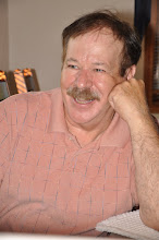
Over breakfast I learned that in fact Lori-Ann Muenzer is a bit of a celebrity.  She informed me that six years ago she had a life changing experience.  Somewhat hesitant (curious, but not wanting to be probing into personal matters), I asked if she cared to share her experience - she responded positively.

I was amazed and impressed to learn that six years ago, at the age of 38, Lori-Ann won Canada's first ever (and to this day only) Olympic Gold Medal in cycling.

Stewart Museum
At an age when most women are enjoying the leisurely life of attending their grand children's sporting events, school band and a host of other activities, Lori- Ann was "beating the pants off" other competitors (some of whom, where perhaps half her age!)

Apparently not one to rest on her laurels, Lori-Ann has her own public speaking company, and is currently working on her degree in photography.

We rode together for the day and eventually connected with highway 37A south and passed through the beautiful Bear Glacier on the way to Stewart, British Columbia.

Stewart British Columbia
Highway 37A south is a short, but fabulously beautiful route which in terms of the glaciations even rivals the Columbia Icefields along the Icefields Parkway (the Bear Glacier's frozen river of ice was an amazing aquamarine color which is sadly lost in the small internet photo).

During its "heyday" it had a population of about 10,000, but today the population of Stewart is less than 500 years-around residents (the summertime population doubles).

In the years following the Klondike Gold Strike, Stewart was a center Canadian mining activity and the Canadian Pacific Railway.  Tucked into a large bay and surrounded by glacier topped mountains, it still has the look of an old Canadian mining town.

Lori-Ann Muenzer in Hyder 
Stewart's huge old Empress Hotel once served as housing for the employees of the Canadian Pacific Railway.  Built in 1908, it still appears - square and upright - as if it were in repairable condition; but (sadly) for what need?


In a similar way, the Stewart Museum serves as stately reminder of better times long past.

From Stewart, British Columbia to Hyder, Alaska is less than three miles; how "neat" it was, to get up in British Columbia, and ride to Alaska for BREAKFAST.

Hyder, Alaska is even smaller than Stewart with a population of only 85 (they must have been hiding when we were there).  Our breakfast was at the  Glacier Inn in Hyder.  It had the atmosphere of an old Western saloon; the "wall-paper" was what must be literally thousands of one dollar bills from nations around the globe, but predominately from the United States.  It seemed as if Wild Bill Hickok could have been dealt his "Dead-Mans Hand" right on this spot.
Glacier Inn in Hyder Alaska
Despite the fact that neither of us had a real travel agenda, we had separate missions and goals which required that we go our separate ways.

We had camped at the same campgrounds Stewart and rode together to as far north as Watson Lake, Yukon Territory before departing on our separate journeys.  Many thanks to Lori-Ann for a "putting-up with me" and Best of Luck with all of your future endeavors.

Tuesday, July 13, 2010

Nez Perce Fight Big Oil

A week ago, while eating breakfast in Kalispell, Montana and glancing through "The Missoulian" (the apparent newspaper of choice in Kalispell), when an article "Nez Perce: No big rigs across their reservation," caught my eye.

I'm ashamed to admit that my first thought was that the Nez Perce were probably "grabbing" on to some environmental issue simply because as Native Americans they wield considerable power.

As I read the article, however, I had to admit that they had a real issue, and in fact it appeared that most of the real "wielding of power" was coming from the other side in the form of some major muscle from, you guessed it, - BIG OIL.

The project is officially known as the Kearl Oil Sands Project and together with the Alberta Tar Sands, it has been called - "...possibly the largest industrial project in human history" (quite a statement).  

The Nez Perce make no attempt to hide the fact that their opposition is not only with the movement of oil field equipment through pristine areas designated as "wild and scenic," but also with the scope of the entire projects environmental impact.

Protagonists for the environment point that this type of mining discharges 3 times the CO2 gasses into the environment that conventional oil field operations do.

Essentially oil sands mining is akin to open pit mining that will have a devastating impact on the environment for years to come (the project is currently slated to continue for a minimum of 50 years).

In terms of the Nez Perce current issues with the project (the movement of oil rig equipment over Native American lands), there seems to be no question that have a very valid concern.

The size of the behemoth truck "rigs" to move the equipment is mind boggling.  They are said to be 12 times the size of a normal semi-truck, are 140-210 feet long, approximately 30 feet high, 25 feet wide and fully loaded will haul loads up to 140 tons (by other accounts - roughly 500,000 pounds!)

Exxon Mobil's current plan calls for them to move the monster sized loads over the winding two lane (32 feet wide) highway - AT NIGHT!  Incredibly believable!

They could of course, in all likelihood, move the needed equipment by using more conventional trucks, but that would jeopardize the sanctity of Exxon Mobil's sacred profits.

It seems that the Nez Perce have valid concerns and I wish them in their efforts.        

Sunday, July 11, 2010

The Canadian Rockies and the Icefields Parkway

From Fort Macleod the plan was to ride to Calgary 107 miles due north and turn west for Banff National Park (Canada's oldest national park established in 1885).  This would be my second time at Banff (another ski trip), but the first in the summer time.

Approaching Banff the white capped soaring peaks began to appear in the distance, but with the overcast skies they were markedly less dramatic (although, they were still a cause to stop and take photographs en-route).


On the ski trip we had actually skied at Lake Louise (35 miles to the north), but had visited Banff in order to see the city and, in particular, the famous Banff Springs Hotel (now the Fairmont Banff Springs).  Built in 1886 by Sir William Van Horne, the manager of the Canadian Pacific Railway, it is still used as a symbol for the Banff area.

The majestic 770 room hotel looks even larger than 770 rooms.  I wanted to capture its splendor, but despite all my efforts, I wasn't able to find the road above the hotel that would provide a clear and unrestricted view for that one - Great Photograph.
Reluctantly resigning myself to accept the photographs "as is" I rode through the center of the bustling city, where hundreds of tourists were seemingly bent expending "their hard earned dollars" before returning from their vacations.  

However, despite the abundance of opportunities, I had no interest in shopping and therefore departed the Banff on a route to Lake Louise.  My intent was to connect with highway 93 and begin on a northward bearing toward Jasper, Alberta.


 A short distance outside of Banff I came to a detour sending me on an off-course route to Lake Louise.  Although being behind schedule (What schedule!), I reasoned that this might in fact be a fun scenic route, and - I was right!  It was barely three miles after beginning the detour, when I rounded a curve where five big horn sheep rams, were peacefully grazing beside the road.

At least they had appeared peaceful; however, before I could remove my camera from my saddle bag, I was startled by the cracking sound of horns crashing together.  I looked up just in time to see the two rams rearing-up and banging there horns together once again.  Although, I missed the photograph, I had "caught" the memory - and it was a memorable sight indeed. 

The distance from Lake Louise to Jasper was 143 miles (230 kilometers), too far to make it before darkness would set in and I was without a clue as to whether there would be any campsites along the route from Lake Louise to Jasper.  Even knowing that Jasper was a national park, I still did not know where the park began and ended.   

The Lake Louise Information Centre provided the needed information; campgrounds were indeed located all along the route separated by 12-20 miles. 

Highway 93 between Lake Louise and Jasper is known as the Icefields Parkway.  The brochure from the information centre called it "The Most Beautiful Road in the World;" a claim that has been reported to them by "many seasoned travelers."  I could not agree more - it is an amazingly spectacular stretch of highway.

With only a few hours to spare before darkness would set in, it was difficult to ride without stopping at each of the numerous stopping points - and even inventing some of my own to "snap" one more photograph - and so, I hit them all (or so it seemed).

After passing up the Rampart Creek campsite, I stopped for gas and was told that the next campsite was "about" 8 kilometers either way (to the north or the south); after 32 kilometers to the north (don't believe all of the information you get) I found the Wilcox Creek campground, a mere 3 miles from the Columbia Icefields Centre, and set up the tent for the night.  

Who would have thought that it would be so cold a 3 miles from the Columbia Icefields (duh!!!)?  Over night the temperature dropped to 4 degrees Celsius (39 degrees Fahrenheit).  Despite of that, I slept surprisingly well.

Riding in the early morning, it wasn't much warmer; and as any "true" motorcycle rider can attest, riding at 40 degrees takes some of the fun away.  After a 32 mile ride to Sunwapta Falls Junction, - coffee never tasted so good!  

Back on the road the air had warmed considerably and the marvel of the Columbia Icefields Parkway continued; but, with a surprising twist.

With only 19 miles of parkway remaining the Athabasca Falls was a pleasant change from the mountains and the glaciers (although their is still no escaping the beauty provided by the mountain as a backdrop to the falls). 


Wednesday, July 7, 2010

Montana and on to Canada

With a late departure from Craters of the Moon Nation Monument the next stop was at an RV Park in Mackay, Idaho.

It had seemed like (when passing through) that "-Utah has more horses than any other state."  It is not true, of course, but from my perspective, through the chosen route of travel, and on a motorcycle - that was my honest perception.

Now, in Idaho there seemed to be little difference (at first).  In Pocatello, local fairgrounds had been preparing for a horseshow, and horses were everywhere.

Nonetheless, as much as the Idahoan's still love their horses the four-wheeler seems to be "taking over" and are the current vogue and now - "they" are everywhere!  The RV Parks are filled with trailers loaded with four-wheelers, they run streets (and even the highways, in smaller towns), are parked at restaurants and (shudder) the bars.

Mackay is small town on highway 93 that seems to caters to four-wheeler's in a big way, and is a prime example of a town taken over by four-wheeler's.  The hillsides leading to 10,000 foot snowcapped peaks are apparently all the invitation that is needed.

Years ago when traveling through Idaho, I remember seeing scores of potato "barns;" but on this trip they seemed surprisingly lacking (was it due to new technology or was it just this area of Idaho?)

Mackay is only about 252 miles from Missoula, Montana, but with stops along way I knew that it was likely to be a two days motorcycle ride - and it was.  The day ended at Hamilton, Montana a mere 40 miles south of Missoula, but since it was a sizeable town with internet cafes and a visible RV park, Hamilton it would be!

Since leaving Utah, it had been a steady progression, a sort of "Greening of America;" and now, in Montana it was as if it had come to full strength.  Take away the mountains, and my thoughts even drifted to Michigan; but not for long, the only similarity is the color green!

Things were piling up, there had been no time breaks between stops, no time to blog, no time to address those nagging prevailing issues we all have and not even time for laundry; and so, it was two days later before gear was loaded on the motorcycle for Kalispell, Montana.

Kalispell was only 167 miles from Hamilton, but it was near the entry to Glacier National Park and therefore a perfect stopping point.

For some unknown reason (perhaps, it was because as a young man I had romanticized visions of going to smoke jumpers school and then working during summer breaks from college) Missoula held an attraction for me, and it was hard to just pass through without stopping; but there was no real reason to stop after only 40 miles, and so it was on to Kalispell.

Kalispell is, as an acquaintance turned friend, described, "is a great place to live and great place to retire;" strange words coming from an unemployed 42 year old man, but as an ex-patriot from Iowa he obviously was infatuated with Kalispell.

With my short time there and my limited exploration, it is hard to pass judgment, but for the sportsman, hunting and fishing abound and it is beautiful country.

My time there was extended as I still endeavored to bring things back together, and as the weather provided three days of on-again, off-again rain.  The mail from Michigan had finally caught up with me and, for the time being, those nagging personal issues had been taken care; and so, despite the weather, it was now time to go!"

And so, with some hesitation (the hope was for clear skies sunshine while riding through Glacier National Park) I loaded the motorcycle and departed from Kalispell to drive through Glacier National Park.

Actually, in spite of the forecast the overcast skies were rather pleasant despite the cool air.  It seemed good to be back on the road after having spent several days in Kalispell.

The road from West Glacier to Marysville (the east side entry to Glacier National Park) travels over Logan's Pass by way of "the Road to the Sun," and winds its way past Lake McDonald and the often times raging whitewater of the Flathead River before reaching the highway's summit at the Logan Pass Visitors Center.

The rain held off for most of the way, and provided some views, but it was hard not to wonder what clear skies and sunshine might have provided.  Sometimes the cloudy skies provide spectacular photos, but it seemed for the most part that such was not to be.

The rain increased as I approached Logan Pass; my finger tips seemed as though they were about to freeze as my gloves were now soaked with rain.  Until then, the rain had been only fleeting, and still it was only a drizzle; but at nearly 9000 feet of elevation, and with air cooled to (an estimated 40 degrees) it was a "bit" of a chilly motorcycle ride!

Even with the rain I could see that Logan's Pass was a spectacular view, but with the rain and cold I bore on without stopping, and arrived at St. Mary's (the eastern entry to Glacier) about 5:30 PM.

With no campgrounds in sight (it was too early to end the day anyway), and hoping to make it well into Canada before nightfall, I continued on.

Given my past record (and knowing that the gas stations are often hard to find in Canada) I made sure that the tank was filled before leaving for Canada.  There was a third reason; of course, the gases prices in Canada can hurt you!

Entering into Alberta from this point, was crossing into unknown territory and I was somewhat surprised by the distances between cities.  When I stopped for the night at Fort MacLeod (a distance of approximately 50 miles) only two cities had been passed.