Showing posts with label traveling. Show all posts

Sunday, July 25, 2010

Haines Junction Yukon Territory - At Last

Mike Howard and Sockeye Salmon
Still determined to make to Haines Junction, I nonetheless, stopped in the Chilkat Bald Eagle Preserve to check with a fisherman there.

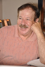
Mike Howard, originally from Palm Springs, California, has been living Alaska for twelve years.  Gregarious and likeable, with a shock of white hair and beard, he characterizes himself as a subsistence fisherman (which has a legal precedence in Alaska).  By law he can gillnet up to a limited number of fish (depending on the breed) for his or his families own consumption.

On the day I was there, he was busy cleaning his catch of sockeye salmon (which he had already gifted to a friend).

Three Photos From Klukwan Alaska
He had a small contingency of friends who kept dropping by (possibly because he apparently made it a practice to give away part of his catch).

Proceeding on my way to Haines Junction, I passed a sign indicating a left turn to Porcupine.  It was still early in the day and Haines Junction was only about a three hour ride and the road towards Porcupine was paved.  And so, I reasoned - why not check it out?

The road to Porcupine crossed over the Chilkat River where a sign at the edge of the roadway proclaimed that this was the historic Dalton Trail, and that nine miles up the road was Porcupine; the site of the Porcupine Mine discovery.

I continued, hoping to find an old Ghost Town and the Porcupine Mine.  Less than a quarter of mile later, the paved road turned to gravel.  Although, not particularly "motorcycle friendly" it was firm gravel with bumps and pot holes, but no sand (I could handle the bumps and pot holes).

Traveling slowly and with care, there were signs of ongoing logging activity, but no mining was evident until at the 8 1/2 mile point, where the road forked and sign was posted "Big Nugget Mine."  A gate potentially blocked the road, but the gate was open, and so I continued on, assuming that since there were no signs warning - "No Trespassing" - it was safe to proceed.

After taking pictures of the Big Nugget mining office, I turned around and left the area - still fearing that I was trespassing.  I never found the old settlement of Porcupine which was said to have had a population of about 500 during the peak mining years.

It was already getting late, but I was having too much fun just exploring; and so, I decided to continue my foolishness.

Turning down one the few side roads, I found the peaceful looking "Chilkat Valley Farm;" a small idyllic pastoral setting neatly tucked into the valley - just "oozing" peace and tranquility.  It was so neatly (or perhaps even, lovingly) maintained homestead that it was almost impossible not to feel comforted by the setting.  I had to assume from the setting that it was a totally organic farm (but there was nothing there to confirm my supposition).

After returning the highway I came to a sign indicating a left turn to Klukwan; since I was on a roll - why not?

I found Klukwan discomforting in a way; in spite of the junk cars and junk "everything" discarded with an "I don't care attitude" there were remnants of a past that showed great pride in what once were architectural homes of character, with beautiful facades that are, even today, impossible to ignore.

Three Photos - on the Road to Haines Junction 
It was sad to see these homes still striving to maintain the dignity that they once held, a dignity that was now lost forever; and it was impossible for me not wonder how the residents of Klukwan could leave buildings and homes, such as these, to decay beyond repair before there very eyes - how sad!

In spite of the "side ventures" the third effort to make to Haines Junction was a success, but it took much longer to cover the 160 miles than one would suspect (about 7 hours). It was not only the side ventures, but the trip itself was one of fantastic beauty; made more unique by the forested mountains and grassy mountainsides.

Monday, July 19, 2010

Alaska and Back Again


The road out of Alaska and back in again, would take me from Stewart, British Columbia (Hyder, Alaska) to Watson Lake, a long ten hour ride.  The road is paved all the way except for a few minor stretches of gravel road along the way (the longest run of gravel is less than 5 miles long).


The gas stops are few and far between; it's no problem, one just needs to be sure to leave with a full tank of gas and not pass up any gas stations in-between.  It's a nice drive, but only moderately scenic (remember, - everything is relative).

My choice (and my recommendation for a campground) in Watson Lake is the Downtown RV Park.  It is conveniently located (as the name suggests) "downtown" and is within walking distance of most everything there is in Watson Lake.  

There is not a lot to see or do in Watson Lake, when we passed through there in March on the snowmobile trip (see the older blog dated March 4, 2010) I failed to get a picture to the famous Watson Lake Sign Forest; therefore I was intent on correcting that error and also looking through the "forest" in effort if there was a sign from close to home.  The "winner" was Jonesville, Michigan (see photo).


The Northern Lights Centre is another Watson Lake attraction that is quite interesting and in my opinion well worth the minimal cost.  Even if one chooses not to see the movie, it cost nothing to tour the small but interesting facility. 

Originally my thought was to go from Watson Lake west to Whitehorse and then north to Dawson City; but, once again, that was the same route I had traveled in March - Why repeat it? 

As it turned out it was a not moot question; torrential rains in Alaska (on a scale that had not been seen in this area in decades) caused flooding which washed out vast sections of highway throughout a purported 100 miles.  The highway is closed until repairs can be completed (an estimated 6 weeks working around the clock - providing that the weather cooperates).

With that one option eliminated another one was interjected - by missing the turn to Whitehorse and continuing straight to Carcross, I could turn south and go to Skagway (the second most, after Hyder, southerly point of entry into Alaska).

 It was an intriguing option, traveling (for me) an uncharted path, even though it would necessitate backtracking back to Carcross in order to continue north through Alaska.  There are no Alaskan roads leading north out of Skagway, the only option was to return via Carcross; unless, it was possible to take my motorcycle by ferry to Haines, Alaska (an even more intriguing option!)


It was a plan I could (and did) get excited about, the decision was made - off to Skagway.

Skagway was the starting point for the White Pass route to the Klondike during the gold rush; a historic town that was bound to be loaded with things of interest.

The only problem getting to Skagway before dark; with so much spectacular beauty to contend with, it all seemed magnificent to ride by with my camera packed away in my saddle bag (I couldn't do it!)  In the end, it was only darkness that made me pack the camera back in the saddlebag. 

Skagway (according to the 2000 census) has a year around population of 862 residents, but it's a volatile population that doubles over the summer tourist season in order to cope with boat loads of tourists that unload from 2-3 huge cruise ships almost daily, the White Pass Railway and a number of tour busses.

In appearance Skagway reminds me of Dawson City, Yukon Territory; but, despite the fact that Dawson City has more than half again the year around population, Skagway appears much larger.  The reason, Skagway has 900,000 annual tourists (15 times more than that of Dawson City's mere 60,000) that encourage more support services.  

With the volume of tourists flocking downtown, the streets are a swarm of activity up until 8:00 PM when the cruise ships depart and all of the numerous tour buses have long since departed; after the 8:00 o'clock hour, one could "drive a dragster" down main street without fear of striking a single sole!


Thursday, July 1, 2010

Utah and Bryce Canyon

Each state seems more wondrous than the last, and yet I know that it is just a matter of the time frame; living in the present makes it so.

I have spent very little time in Utah and it has always been while just passing through or on a ski trip which gives one a very limited perspective.  In traveling through Utah now, it's as if I'm seeing the state for the first time, and I like what I see!

Although, even now, I know that my time here will be all too brief, but I'm happy to have the opportunity to relish as much as possible.

My image of Utah is of giant sandstone multi-shaped rock formations and that image seems ever present, but then too, there is another image that seems out of context.  This is an image that I was surprised to find; but as I traveled north out of Kanab there were beautiful peaceful looking valleys, winding streams, an elk farm and green grassy areas (although, still framed in the sandstone cliffs) that contrasted sharply with the otherwise harsh desert like terrain.  This tranquility, however, seemed short lived as I turned east towards Bryce National Park my original image was restored.

It was mid-afternoon as I rode into the aptly named Red Canyon, the gateway to Bryce Canyon.  Red Canyon is still outside of Bryce Canyon itself and is a drawing card all by itself with numerous outfitters, backpackers and horseback trail riding tours being offered to lure prospective tourists.

As I rode through Bryce Canyon I couldn't help thinking that it would be a great parwondrous,living in the present,Utah and Bryce Canyon,traveling,peaceful looking valleys,campgrounds,riding tours,riding the motorcyclek for backpacking.  There is so much to see from the overlooks, but I would have very liked to have experience the views from the bottom of the canyon.

From one end of the park to other is a mere 16 miles, but it is a spectacular park with great and unusual vistas.  Despite its relatively small size, following the winding road through the canyon and stopping to experience and photograph the great vistas, I found myself running short of time.  At the eleven mile point I turned around in order to exit park or find a campsite at one of the numerous campgrounds within the park.

It was approaching dusk as I turned into one of the north end campgrounds near the entry to the park.  There was still space available, but although I knew this would be my cheapest alternative I exited the campground and the park (I was hungry there wasn't any food available inside the park at this hour).                              

What I thought was perhaps my next best choice, Ruby's Inn Park & Campground and Motel, was built in 1919 to service tourist visiting Bryce Canyon and was first known as "Tourist Rest.  Despite its long history I would give it a "3" on a scale of one to ten.

From my experience, I found Ruby's Inn to be both expensive and ill equipped (only one of the two bathroom facilities have showers and there are no paved roads), which is appalling considering their prices.  My recommendation for anyone going there would be to find a spot within the national park (their still will not be any paved roads, but there are at least showers) and you will save money too boot.

I should add that my harsh assessment of Ruby's was further aggravated by the fact that the only food they had available was grocery store snacks.  The only reason I had stopped there in the first place was in order to get both food and a camp site; but by that time I was too paranoid about the very real possibility of hitting a deer or elk to risk riding the motorcycle even for the short ride back to the campground inside the park.