Tuesday, August 10, 2010

Airboating and the Denali National Park

Rich and Kathy
Back in Fairbanks once again, I was trying to explore some of the things that I might missed the first time around when I ran into Rich and Kathy Stone outside of the Silver Gulch Brewing & Bottling Company.  Rich was formerly from Michigan's UP (Upper Peninsula) and in spite of the fact that they were out to celebrate their sixth anniversary, they asked me to join them for dinner (I didn't want to intrude on their special occasion but they insisted).

Over dinner Rich (a welder by profession) told me that he had just finished building an airboat for a friend and asked if I had ever ridden in an airboat; my answer was - never.

As result of our conversation I spent the night at Rich & Kathy's (pitching my tent outside, out of respect for the special occasion); and the next day we went airboating with Kurt (the owner of the airboat) and Thomas (one of Rich's co-workers).

Kurt, Rich and Thomas & the Stone Built
No small boat, the "Stone Built," is a 19'- 6" airboat with a 456 cubic inch Chevrolet engine that has been stroked to 496 cubic inches and puts out 600 Horse power.  It is a beautiful boat with 1/8" thick side walls and 1/4" on the bottom which is covered by approximately 5/8" of plastic (neoprene?) which protects the boat from abrasion and reduces friction in the shallow water.  Rich is justifiably proud of his work.

We put in on the Chena River and boated around for about three hours over water that at time was less than six inches deep; but it was no challenge for the "Stone Built".

Cruising the Chena
The Chena is a sizeable river at the point where we put in and there are a number of year around homes that lined the banks for short distance off the highway, before the service access roads gives out and the river becomes the only link back to civilization.  Still there were a number cabins providing temporary housing for those who favor the solitude provided by the limited access.   For them their small cabin in the wilderness is their own little "Peace of Heaven".

After packing up and thanking my hosts, Rich and Kathy, I departed for Denali National Park.
From Fairbanks it is over a 5 1/2 hour ride to Denali and I hoped that the clear and sunny skies would hold together for the entire distance, but such was not the case.

However, I rode in and out of the rain and arrived in Denali with clear and sunny skies once again.

Cabin on the Chena
As expected, Denali has the look and feel of the major resort it is, but surprisingly, I was a able to find a campground for $8 a night (plus four dollars for a shower) - an unexpected bargain.  The Denali Outdoor Center is located on the west side of the highway just to south of the town of Healy.  The only drawback (a minor one) it is about ten miles north of Denali; but it is neat and clean and provides the added perk of whitewater rafting directly out their facility without having to go anywhere.

The half day rafting adventure on the Nenana River was less than $90 and well worth the price.  You can choose between either the scenic trip or the canyon whitewater route - or take them both for about $120.  Having been told that the scenic trip was more or less just a float trip, I went for
Load it Up!
"the whitewater adventure."

Riding in the front of the raft, I was glad for the protection that the dry suit provided from the icy waters fresh off the glacial melt.  The class 3 & 4 rapids through which we passed were not life threatening, but were nonetheless, truly a "BLAST".  With "Thirsty" (one can only guess how he got that "moniker") at the helm - barking out orders - we roared our way through the rapids; whooping, yelling and "high-fiving" as we went.

The  Winding Nenana River
Despite its monstrous size (6.2 million acres - about the size of the state of Massachusetts), Denali is only the third largest of our national parks.  Wrangell-St. Elias National Park is the largest and the second largest is the Gates of the Arctic National Park.  The four largest of America's national parks are all located in the state of Alaska (Less you have to Google it - #4 is the Katmai National Park).

I had been looking forward with a great deal of anticipation to going to Denali National Park, and it truly is a very special and spectacular place; nonetheless, I was disappointed.

In my anticipation, I had perceived riding through the park and enjoying the sights and sounds at my own leisurely pace, but it was not to be.

Of the ninety miles of the only main roadway leading into Denali, only the first 12 miles are accessible to the general public by a wheeled vehicle of any type.  For many of us, Mt. McKinley is the focal point of the park, but is more than seventy-five miles (as a crow flies) from the park entrance.  Wonder Lake, some 80 miles into the park; one is still 25 miles from Mt. McKinley.

Motorcycling Along Denali's First 12 Miles
Despite what I've said, Denali (which derives its name from an Indian word meaning "the Great One") is surprisingly accessible to anyone who has the time, energy and inclination to explore its environs.  Even though Denali is the habitat of black bear, grizzly bear, moose, wolverine and caribou, hikers and bicyclers are free to roam the park (seemingly uncontrolled).

Unfortunately, for the greatest number of tourists, who are traveling by vehicle are limited to the first 12 miles before being "herded" aboard one of the multitude of school busses turned tour-bus.  Their best hope is to just get a glimpse of wildlife with the aid of field glasses and looking out the pulled down bus window.

Dall Sheep Rams
We saw a number of animals over the course of the our eleven hour bus ride, but I was less than excited by the bear and caribou that I saw from about 400 yards away and even the Dall Sheep that were at least worthy of a photo shot (the photo would have been great with the proper lens and tripod).  For the most part, however, I was dismayed for the loss of photographic opportunities(mostly scenic) over which I had no control.

In fairness, it must be said that one is free to get off the bus at any point along the route and get back on another bus going in either direction.  Sounds fine, but I for one would rather travel along the roadway at my own pace, stopping and photographing, hiking or just relaxing at will; harboring no feelings of guilt for bothering the other passengers.  

Foothills of Mt. McKinley
The park service claims that the reason for not allowing the general public free access to theentire ninety miles of roadway, is there desire to control the traffic flow.  Forgive me for being suspect, but I had no difficulty motorcycling along the first twelve miles of roadway; my suspicion is that its - "All About Money".

The park service, no doubt, receives (as well it should) a healthy stipends from the privately run enterprise which holds the right to run busses through Denali National Park.

Friday, August 6, 2010

Discretionary Move

Home on the Range (note tent)


Coldfoot with a population of 13 year around residents is a busy place during the summer a
population of, perhaps, 10 times the year around residents.  The "Sourdough" gas station,
restaurant, bar and hotel is the focal point of the community.

Although the camping is free, it all works out in the end - the showers are $14 plus $5 per towel
(yesterdays T-shirt, works just fine).  The food and drinks are equally exorbitant (not the place
to languish away your time).
Christian (left) & Jon

Riding north from Coldfoot and hoping that the clear skies would hold on, while at the same time
doubting that Mother Nature would be so kind, I began once again my quest to reach Prudhoe Bay.

The further north I rode the more in doubt the situation became, but the rain was holding off for
the time being; and so, there was no point in stopping.

About 90 miles north of Coldfoot it began to rain, ever so lightly, but I knew it would take very
little rain to turn the Dalton into an "ice rink".

Sure enough, I began to feel my front tire get "squirrelly" and almost immediately pulled to the
side of the roadway - I just could not (I told myself) afford to lay my Harley down.

Soggy Buddies
I waited astride my Harley, kick-stand down, helmet off and hood of my rain suite over my head;
resting and even striving (to no avail) to sleep - what else was there to do?


Not wanting to give up and knowing that I had no business on the Dalton Highway (AKA - "The Haul Road") in the drizzling rain; I decided look for a spot along the side of the Dalton to pitch my tent.  It didn't look good; the river flowed barely forty feet from the highway and between it and the roadway was mostly a mixture of shale and rocks.


Nonetheless, I found a spot, and while erecting my tent a solo rider, traveling south on a Honda,
stopped to inquire as to my situation; and so doing informed me that he had laid down his
motorcycle, wiped out a running light and added "character marks" to the side of his bright red
Honda - I knew I had made the right decision.

I asked him if he had an extra bottle of water I could buy.  He gave me his last bottle and refused
any money, and quietly went on his way.

Even after seeing the results of trying to conquer the Dalton, I was beginning to question just
what I was doing; but, as the rain commenced once again, I returned to finish setting up the tent.

Comfortably laying in my tent and listing to the patter of rain and the bubbling of water from the
near by creek bed, I rested for perhaps an hour before realizing that the rain had stopped;
although it was clear that the sun had not made its presence known.  And so, I continued resting,
knowing that the brief repose from the rain was not enough to allow the Dalton to dry out; but my
guilt was getting the best of me, and I bailed out of the tent.  All the while knowing what to
expect, but hoping for some kind of a miracle that was not to be.

Scenery on the Slippery Dalton Highway
While standing on the roadside, anguishing over my dilemma, a truck bearing pipeline lettering
pulled up and handed me a Gatorade and a couple of snickers - another motorcycle rider had asked
him to give it to the "biker in the tent at the side of the road" (my Honda "friend" whose name I
never knew).

The driver asked if that was all of the food I had and handed me a couple of energy bars and
another water- more, kindness without question.

Sprinkling once again, I retired back to my meager abode; only to be alerted once more by the sound
of a motorcycle pulling off the highway.  The sprinkling was now a steady drizzle.

This time it was another Harley, also northbound, but accompanied by a Jeep with a lone driver.

Beauty in the Haze
The three of us conversed for a while, each of us offering his assessment of the situation and
coming to the same conclusion.  It wasn't worth the risk!

Jon on the Harley and Christian driving the Jeep were on separate journeys, but after bumping into
one another repeatedly they decided to go tandem.  Strangely, Jon from New Hampshire and Christian
from Missouri were both tattoo artists; a fact, that almost certainly brought them together.

At this point, we were about 35 miles from Atigun Pass and only an approximate 150 miles from
Prudhoe Bay.  There was so much "scuttlebutt" about the Dalton; some said that "once over Atigun
Pass you had it "made," and others claimed it mattered not - "it was all the same."

The Mountain & the  Pipeline
I thought that perhaps Christian could be talked into throwing together with his "compadres" and
the three of us going the distance to Prudhoe; but even with his Jeep - he had a fear of the Dalton
Highway and wasn't buying it; despite my persistence.  

Nonetheless, they agreed to wait for me to break camp and pack my gear; I was grateful to have some
accompaniment.

When we arrived back at Coldfoot it was after 2:00 AM and dark enough to tell that you had your
lights on.

Coldfoot stays open around the clock, selling gas, rooms, cold sandwiches and coffee.  At this
Overcast & Rain on the "Haul Road"
point, food was food and coffee - was the order of the day.  

Jon and Christian were still drinking coffee when I left the restaurant to set up the tent once
again.  When I awoke in the morning they had already departed (as planned) and I returned to
Fairbanks, pleased to have a day without event.

They say "Discretion is the better part of valor"; but that doesn't lessen my disappointment for
not making it to Prudhoe.

Thursday, August 5, 2010

Inside the Arctic Circle

Too Close!
With a new accessory added to my Harley motorcycle (a 2 1/2 gallon gas can) I was ready to depart for the Arctic Circle and beyond, or so, I thought.  I had barely gotten on the Steese Highway when I came to a sign for the turn-off to Chena Hot Springs; remembering a conversation I had at the
Boatelo (a local watering hole) where a patron had advised me that only 58 miles from Fairbanks, on
the road to Chena Hot Spring, "...you're likely to see moose and possibly even a bear."

Taking him on his word, I rode the 58 miles and found that his advice was sound.  On the way I
indeed saw two moose and was able to get close enough for a good photo (probably, once I was again
Thankfully - On the Opposite Bank
closer than I should have been.)  I approached cautiously (or so I thought) and snapped off about
four quick shots of the large cow; she looked directly at me (seemingly undisturbed by my
presence).

Apparently, such was not the case; as I turned to walk away, I suddenly was alarmed by the sound of
rustling water, as if an entire bathtub of water had suddenly been dumped into the creek.  Turning
back around, already fearing that I was being pursued by the huge animal, I was relieved to find
her already standing on the opposite bank with water streaming from her body.  I knew immediately
that I had gotten "way too close".  If the beast (and a moose is indeed a beast) had decided that I
was somehow a threat, and had came my way instead of towards the opposite bank - I could never have
escaped.

Days later I was told that moose kill or injure more people than bears; mostly due to the fact that
tourists seeking to capture a photograph have less fear of a moose than a bear and approach (as I
had done) - way too close!


My reason for going to Chena Hot Springs was simply in hopes of seeing wildlife and having succeeded I had no interest in swimming in the hot springs or continuing my stay and therefore departed.


From Fairbanks to the Yukon River bridge is a distance of on hundred and thirty miles, and my side
venture to Chena Hot Springs had assured me that I could not make it that far before the late in
the evening (not that it mattered - it would still likely be daylight, whatever the time.)

Pipeline Going Underground
Despite my eagerness to get on the road I couldn't resist stopping at the Alyeska pipeline (Alyeska is the service that installed and services the Alaska Pipeline) viewing station along the Steese Highway just north of Fairbanks.  Although I knew that the pipeline closely parallels the Dalton Highway, I wasn't sure if there would be other points with such easy access.  Actually, there no shortage of opportunity to view the pipeline as in snaked its way across the frozen tundra, burrowing underground and passing under bridges and over mountains.  

Having loss more time and still wanting to put some distance between my final stop for the night
and Fairbanks, I continued north.  The hope was to at least make it off the Elliot Highway (itself
a picturesque ride along a winding roadway with roller coaster mountainous terrain) and onto the
Dalton Highway.  If only for purely symbolic reasons, it marked (for me at least) the start of the
trek to Prudhoe Bay.

Motorcycling north ever mindful of that schedule that didn't exist (old habits die hard) I couldn't
resist stopping to photograph the wondrous beauty.  At times the mountains take on a surrealistic
quality - looking more like a painting than an actual photograph.  I found myself repeatedly
examining the results of my efforts; only to confess in the end, "Yep, that's what it looks like!"

Although I had still not made it to the Dalton Highway and it was (of course) still daylight, I
pulled off the Elliot Highway.  The Dalton Highway would have to wait until tomorrow.  What the
sign had indicated to be a campground was in truth nothing more than a pull-off - in any case, it
was home for the night.

In the morning, hungry and un-cleansed, I continued north for Coldfoot - today's destination.
It wasn't long before the Elliot reached the Dalton Highway; a bit of misnomer by normal standards,
but this is Alaska and the Dalton is indeed a "highway," albeit gravel (or mud) in many parts.

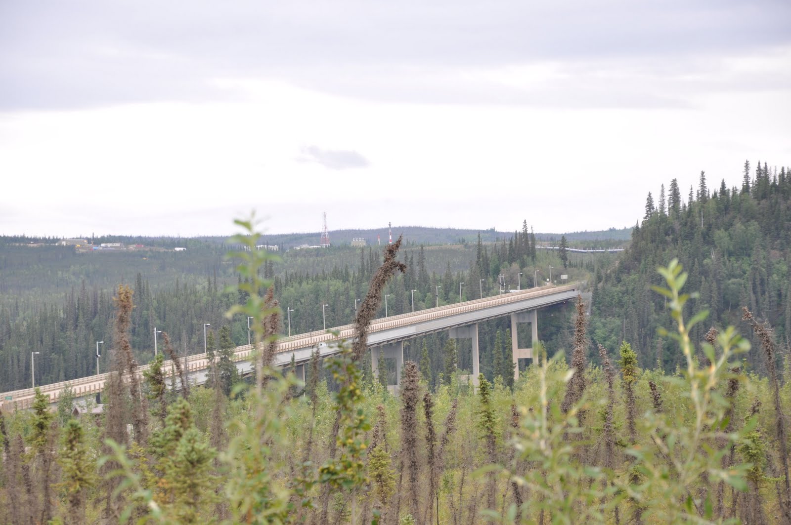
Yukon River Bridge
A 140 miles north of Fairbanks, the road crossed over the mighty Yukon, the fifth longest river in
North America, and the only gas stop between the Road House (16 miles north of Fairbanks) and
Coldfoot.
Impressive as the bridge is, it was impossible not to question - "how it was not a formidable
problem to cross the wood beamed roadway when it was heavily laden with winter snow."  Even with
sand on the roadway or chains on the tires, it's hard not to wonder just how well it works.
Surreal Photo

Between the Yukon River Bridge and Coldfoot lie two major points of interest - the Arctic Circle
and Finger Mountain.

The first one - Arctic Circle - marks the northern most point of the summer solstice and the
southern most point of the winter solstice.  In other words, it is that line of latitude at which,
Finger Mountain
during the northern summer solstice (June 21St) there is "at least" one day when the sun never
sets, and during the northern winter solstice (December 21) "at least" one day of total darkness.

Finger Mountain, the second major point of interest is not much of a mountain at all, little more
than a hill to the normal eye, but it is an anomaly to the region; formed from lava outcroppings
300 million years ago when rock pushed though the earths crust and changed the landscape forever -
it is a unique feature of the artic tundra and stands out, "like a sore - FINGER!"

Monday, July 26, 2010

Haines Junction to Tok and Fairbanks Alaska

Beauty of the Canadian Rockies at Haines Junction, Yukon Territory


It's been a week since I left Haines Junction, Yukon Territory for Alaska, but you're just reading of that fact on yesterday's blog.

I am now in Fairbanks where I've been for the last five days.  From Haines Junction I traveled northwest to Beaver Creek the western most community in Canada, near the Alaskan border and then went west to Tok, Alaska.

The road from Dawson City, Yukon to Tok, Alaska (closed as result of the floods) was opened the day after I arrived in Tok, but I understand that it is still slow going and definitely sub-standard conditions.

Kluane Lake, Yukon Territoty
From Haines Junction to Tok, Alaska continued to be a thing of beauty.  As it past the region of Kuane Lake the scenery took on a new and different, but still beautiful look.

After a day and a half in Tok, I departed for Fairbanks having remained in Tok only in an effort to avoid the threats of rain.

The road to Fairbanks was excellent, although, devoid of any scenic beauty.  At least the weather had warmed up considerably and I arrived in a dry condition.

Surprisingly Fairbanks actually receives very little rainfall; with just 11 inches annually it almost qualifies for desert classification (by definition a desert receives less than 10 inches of annual precipitation).

Kluane Lake, Yukon Territoty
Fairbanks has all of the amenities of a big city without the typical big city congestion.  With a 2008 estimated city population of 35,132 that swells to a metropolitan area of 97,000.  Fairbanks also lays claim to the widest temperature spread of any city in the world, from -66 degrees to 99 degrees Fahrenheit.

This past week Fairbanks has been celebrating its Annual Golden Days Celebration which is accompanied by the World Eskimo and Indian Olympics (complete with events such as the ear pull, blanket toss and two legged kick) and included a Saturday morning parade.
______________________________________________________________

Many years ago the popular saying of the day was various versions of - "I just need time to find myself".  It seemed to be most commonly repeated by the young restless souls who were struggling to find their place in the world.

Kluane Lake, Yukon Territoty
It was never a comment for which I ever felt a kinship; I thought it was too much of an escape from the realities of life.  I always believed (rightly or wrongly) that I knew what I wanted to be and where I was going.

However, today I find myself harking back to that yesteryear and finding a new reality, a reality with which I am still not all that comfortable.

Like it or not I am a bit of a lost sole; not in a sad or lonely way, but in a sense that I am searching for new meaning and purpose in my life.

Strangely, and somewhat incongruent with what I've just said - I love my wandering ways!  I just feel a need to bring a meaning or purpose, into all that I do.

Blanket Toss at World Eskimo-Indian Olympics
No matter how much we tell ourselves that, "I don't care what other people think;" the reality, for most of us is - that we really do care!  We need that moral support (or at least we need to "feel" that it exists) in order to carry forth with our daily lives.  Perhaps, I should not be so bold as to presume what "others" think or believe; when I say "we" it is used only in the context that I believe that their are others of you out there, with whom I share that common bond.

And so I continue my quest to "find myself," - but I don't like it!

I would like to travel north to Prudhoe Bay, but that is a five hundred mile trek on mostly gravel roads with miles between gas stops.  I don't know how far I could go on my Harley; most motorcycle riders who go that way are riding BMW's, Kawasaki's or Yamaha's with tires designed to handle the gravel and mud terrain.

Golden Days Parade - Fairbanks
Maybe if I got fitted with pair of "knobby tires" on my Harley, in order to handle the gravel and mud, it would an attainable goal.  Even then, however, I would need a bit of luck; but then, - ...luck is very thin wire between survival and disaster and not many people can keep their balance on it."  ("Author's Note by Hunter S. Thompson" - "Fear and Loathing in America").

It would probably be stupid, absurd or even a little insane just to try the trip on a Harley - Got to Go!
                        
                          _________________________

The above was completed yesterday (7/25/10) and deliberately held for posting today; but now, today is here and I have received more information - both good and bad.

Some say that the belt drive won't handle the abuse of the Dalton Highway, others say that there are a lot of Harleys that make the trip, all say - it's a beautiful trip.

It's 499 miles from Fairbanks to Prudhoe Bay with the last half being all gravel; I'm heading north and at least as far as Coldfoot (which I've been told is all paved and the approximate halfway point).

Sunday, July 25, 2010

Haines Junction Yukon Territory - At Last

Mike Howard and Sockeye Salmon
Still determined to make to Haines Junction, I nonetheless, stopped in the Chilkat Bald Eagle Preserve to check with a fisherman there.

Mike Howard, originally from Palm Springs, California, has been living Alaska for twelve years.  Gregarious and likeable, with a shock of white hair and beard, he characterizes himself as a subsistence fisherman (which has a legal precedence in Alaska).  By law he can gillnet up to a limited number of fish (depending on the breed) for his or his families own consumption.

On the day I was there, he was busy cleaning his catch of sockeye salmon (which he had already gifted to a friend).

Three Photos From Klukwan Alaska
He had a small contingency of friends who kept dropping by (possibly because he apparently made it a practice to give away part of his catch).

Proceeding on my way to Haines Junction, I passed a sign indicating a left turn to Porcupine.  It was still early in the day and Haines Junction was only about a three hour ride and the road towards Porcupine was paved.  And so, I reasoned - why not check it out?

The road to Porcupine crossed over the Chilkat River where a sign at the edge of the roadway proclaimed that this was the historic Dalton Trail, and that nine miles up the road was Porcupine; the site of the Porcupine Mine discovery.

I continued, hoping to find an old Ghost Town and the Porcupine Mine.  Less than a quarter of mile later, the paved road turned to gravel.  Although, not particularly "motorcycle friendly" it was firm gravel with bumps and pot holes, but no sand (I could handle the bumps and pot holes).

Traveling slowly and with care, there were signs of ongoing logging activity, but no mining was evident until at the 8 1/2 mile point, where the road forked and sign was posted "Big Nugget Mine."  A gate potentially blocked the road, but the gate was open, and so I continued on, assuming that since there were no signs warning - "No Trespassing" - it was safe to proceed.

After taking pictures of the Big Nugget mining office, I turned around and left the area - still fearing that I was trespassing.  I never found the old settlement of Porcupine which was said to have had a population of about 500 during the peak mining years.

It was already getting late, but I was having too much fun just exploring; and so, I decided to continue my foolishness.

Turning down one the few side roads, I found the peaceful looking "Chilkat Valley Farm;" a small idyllic pastoral setting neatly tucked into the valley - just "oozing" peace and tranquility.  It was so neatly (or perhaps even, lovingly) maintained homestead that it was almost impossible not to feel comforted by the setting.  I had to assume from the setting that it was a totally organic farm (but there was nothing there to confirm my supposition).

After returning the highway I came to a sign indicating a left turn to Klukwan; since I was on a roll - why not?

I found Klukwan discomforting in a way; in spite of the junk cars and junk "everything" discarded with an "I don't care attitude" there were remnants of a past that showed great pride in what once were architectural homes of character, with beautiful facades that are, even today, impossible to ignore.

Three Photos - on the Road to Haines Junction 
It was sad to see these homes still striving to maintain the dignity that they once held, a dignity that was now lost forever; and it was impossible for me not wonder how the residents of Klukwan could leave buildings and homes, such as these, to decay beyond repair before there very eyes - how sad!

In spite of the "side ventures" the third effort to make to Haines Junction was a success, but it took much longer to cover the 160 miles than one would suspect (about 7 hours). It was not only the side ventures, but the trip itself was one of fantastic beauty; made more unique by the forested mountains and grassy mountainsides.

Friday, July 23, 2010

Haines Alaska

Ferry From Skagway to Haines

Everything worked as hoped; it was indeed possible to take the ferry by motorcycle and go either to Juneau or Haines, Alaska.  Juneau (while it would be nice to see the capital city) would still leave me landlocked; there are no roads in or out of Juneau.

At the rate of $100 each way, Juneau was never a viable option, and in the morning I left for Haines.

The ferry ride was somewhat disappointing, the anticipated souring glaciers were no where to be seen.

In contrast, Haines is a beautiful city; or more accurately, it is a beautiful setting.

Looking across the bay my eyes were drawn to the site of the large homes that adorned the mountainside.  As picturesque as the view was, however, the clouds so thoroughly obscured the mountains that, it was not until later when I saw that very image displayed frequently around Haines and on brochures promoting the area, when I fully realized I was missing much of what must be a truly breathtaking sight - the souring mountain peaks, as a backdrop to Fort Seward, that make the image a favorite of artists and photographers alike.
  
I did not realize at the time that I looking at the site of the military base of old Fort Seward, but I knew that the site would be my first stop.

Even though, as captivated as I was by the sight of the large homes across the bay of open water
I would never see that entire image in its full glory.  Unrelenting, the clouds never broke.

Today the large buildings that once served as officer quarters, administrative headquarters, medical centers and the like, have now been converted into hotels and condominiums.  Further below them and across the old parade and exercise field stands the one remaining (of the original two) huge 2 1/2 story barracks building.  Too costly to repair, it stands as a sadly decaying hulk.

The setting was perfect, my campsite was owned by the Halsingland Hotel (one of the hotels converted from the old officers quarters); and was low priced, had WiFi, showers, laundry and a bar/restaurant - all of the amenities of home!

Smaller and lacking the hoards of tourists that highlight Skagway, the main claim to fame for Haines is the Chilkat Bald Eagle Preserve; the site of the largest collection of bald eagles in the world.

Fort Seward From Across the Bay
Unfortunately the season for seeing eagles in mass is during the months of October and November.  I was told there are thousands of the big birds at that time who are not only prominently visible, but easily approachable to within a few feet.  The reason is that during this time, the eagles in committed feeding frenzy; basically the "lid is off the cookie jar" in the form of dying salmon which are gobbled up by the eagles.

The next day, having completed my tour of Fort Seward, I rode out to Chilkat State Park hoping to catch sight of the black bears (a mother and two cubs) that had been reported to be in the area.

The fishermen were already wading the in the waters of the Chilkat River (hoping the hook one of the early salmons just beginning their annual run up the river); but no bears were seen.  I would have to wait until two days later (when on the ride from Haines to Haines Junction, British Columbia) to catch sight a seemingly friendly bear, caught idly munching at the roadside.

Almost too "seemingly friendly;" unconcerned by my attention, the temptation was to slowly approach closer to get a better photograph.  I had to caution myself, remembering that "this after all a wild black bear" that if threatened by my advance would perhaps - Well, I just didn't push it!

The  Barracks at Ford Seward
However, I'm getting ahead of myself.  After returning from the state park, I went over to the hotel to address their WiFi.  While there working on my computer, I met the congenial Elize Winby Wall who was also working on here computer.
                
We conversed and I learned that she was a casualty of computer downsizing, we discussed are seemingly similar situations - both of us retired, but neither if us by choice!

She said that it was the best thing that ever happened to her; she would have otherwise never started traveling and fully enjoying life - in her words, "I'm having a ball!"

Halsingland Hotel (on  right)
A licensed pilot, who has her own plane, she informed me that her husband (also a licensed pilot) was killed in an aviation accident, and that she had only recently returned to flying herself.

Starting anew - along with her companion, a dentist (and pilot - of course!), have more freedom than most to enjoy life's many wonders; and they seem to be doing quite well - thank you!

Another commonality, Elize is also a bloggers (www.dogfishstudio.com); the people you meet on the road are often the hi-light of traveling.

Monday, July 19, 2010

Alaska and Back Again


The road out of Alaska and back in again, would take me from Stewart, British Columbia (Hyder, Alaska) to Watson Lake, a long ten hour ride.  The road is paved all the way except for a few minor stretches of gravel road along the way (the longest run of gravel is less than 5 miles long).


The gas stops are few and far between; it's no problem, one just needs to be sure to leave with a full tank of gas and not pass up any gas stations in-between.  It's a nice drive, but only moderately scenic (remember, - everything is relative).

My choice (and my recommendation for a campground) in Watson Lake is the Downtown RV Park.  It is conveniently located (as the name suggests) "downtown" and is within walking distance of most everything there is in Watson Lake.  

There is not a lot to see or do in Watson Lake, when we passed through there in March on the snowmobile trip (see the older blog dated March 4, 2010) I failed to get a picture to the famous Watson Lake Sign Forest; therefore I was intent on correcting that error and also looking through the "forest" in effort if there was a sign from close to home.  The "winner" was Jonesville, Michigan (see photo).


The Northern Lights Centre is another Watson Lake attraction that is quite interesting and in my opinion well worth the minimal cost.  Even if one chooses not to see the movie, it cost nothing to tour the small but interesting facility. 

Originally my thought was to go from Watson Lake west to Whitehorse and then north to Dawson City; but, once again, that was the same route I had traveled in March - Why repeat it? 

As it turned out it was a not moot question; torrential rains in Alaska (on a scale that had not been seen in this area in decades) caused flooding which washed out vast sections of highway throughout a purported 100 miles.  The highway is closed until repairs can be completed (an estimated 6 weeks working around the clock - providing that the weather cooperates).

With that one option eliminated another one was interjected - by missing the turn to Whitehorse and continuing straight to Carcross, I could turn south and go to Skagway (the second most, after Hyder, southerly point of entry into Alaska).

 It was an intriguing option, traveling (for me) an uncharted path, even though it would necessitate backtracking back to Carcross in order to continue north through Alaska.  There are no Alaskan roads leading north out of Skagway, the only option was to return via Carcross; unless, it was possible to take my motorcycle by ferry to Haines, Alaska (an even more intriguing option!)


It was a plan I could (and did) get excited about, the decision was made - off to Skagway.

Skagway was the starting point for the White Pass route to the Klondike during the gold rush; a historic town that was bound to be loaded with things of interest.

The only problem getting to Skagway before dark; with so much spectacular beauty to contend with, it all seemed magnificent to ride by with my camera packed away in my saddle bag (I couldn't do it!)  In the end, it was only darkness that made me pack the camera back in the saddlebag. 

Skagway (according to the 2000 census) has a year around population of 862 residents, but it's a volatile population that doubles over the summer tourist season in order to cope with boat loads of tourists that unload from 2-3 huge cruise ships almost daily, the White Pass Railway and a number of tour busses.

In appearance Skagway reminds me of Dawson City, Yukon Territory; but, despite the fact that Dawson City has more than half again the year around population, Skagway appears much larger.  The reason, Skagway has 900,000 annual tourists (15 times more than that of Dawson City's mere 60,000) that encourage more support services.  

With the volume of tourists flocking downtown, the streets are a swarm of activity up until 8:00 PM when the cruise ships depart and all of the numerous tour buses have long since departed; after the 8:00 o'clock hour, one could "drive a dragster" down main street without fear of striking a single sole!