Saturday, August 28, 2010

Seward Alaska

Sea Lions and Birds of Resurrection Bay


The morning was clear and slightly overcast (kind of an A-typical day of late), but by noon I found myself once again begrudgingly donning the rain gear and riding through a cold 55 degree mist.  It was still raining when arrived in Seward an hour later.

A fair size community by Alaskan standards, Seward has a population of 3016 year-around residents that jumps dramatically in the summer when Seward becomes a main stop on the Alaskan circuit.

The "Spires" of Resurrection Bay
The main attraction is, of course, the Resurrection Bay and the associated: fishing, humpback and orca whale watching, sea lions, eagle and bird watching; together with the camping and hiking in the nearby (less than ten miles) Exit Glacier and the trail to the Harding Icefields, there is no shortage of things to do and see in Seward.
           Kenai Fjords National Park - Bear 

Glacier


The small tourist ship (100 passengers) I took was affordable, fun and featured an all you can eat prime-rib buffet.  Although no whales were sighted, we did see eagles, mountain goats, stellar sea lions and puffins and other birds.

Before leaving Seward I hiked the short trail to Exit Glacier.  A barrier blocked the trail leading to the edge of the glacier, but it looked to be safe and appeared to lead to the very edge of the glacier.
Exit Glacier

Seeing no park rangers in the vicinity I decided to slip through the barrier and walk down to the glacier's edge.

I touched the glacier and verified that it was indeed ice, but resisted the strong temptation to walk on the glacier itself.  Thinking that - in the unlikely event that I would slip on the ice and somehow injured myself - I would be in real trouble, I returned back to where I belonged; only to be confronted by park ranger.

Blue ice viewed from - Up Close and Personal
He asked in a voice loud enough to be heard by the other tourists standing nearby, "What are you doing crossing the barrier and going into the secured area?"

"I just wanted to get closer to the glacier," I replied".

"Do you also want to pay a $5,000 fine and spend six months in jail?" he asked.

"No, I didn't read the penalty," I replied.

Now lowering his voice he said, "That's alright, I like to break the rules myself - I just had to say something for the benefit of the others who saw you."  "Just be careful."  Park rangers are real people too!

View From the Edge of the Icefield
As I thanked him and departed, he spoke to the crowd and said in a loud voice, "I guess I got him straightened out;" and turned back too me with a smile!    

I spent 3 days in Seward and could have easily spent more.  It's a casual town that hosts a friendly easy going environment - it's hard not to like Seward Alaska.

Thursday, August 26, 2010

Hope Alaska - Lost in Time

Still on the road heading back to Michigan; it's fast travel and not much time for fun - not the way to travel.  All of the following preceded my departure from Alaska.
                              ________________________________________________

After breaking camp from the Chugach State Park in Eagle River I made a brief stop in Anchorage at the local Harley dealer "House of Harley-Davidson" to replace a burned out headlight (thought I might need that!)

In spite of what other travelers had told me, Anchorage seemed to be a very livable city, not seem at all like the center of mass confusion that I had expected.

The started out with clear conditions, but by the time I left the dealership it had returned to what was beginning to seem like the norm - varying between overcast skies, misty rain and 50 degree temperatures.

Given the conditions, what was a truly beautiful area was made less so and offered greatly diminished photographic opportunities; but, despite this, I was surprised to see two hardy souls windsurfing in the Cook Inlet.

Motorcycling in the rain has become such a norm of late that it is not all that unbearable anymore, but when it is combined with cold 50 degree temperatures it becomes hard to tough it out and the frequent stops to warm up make for a long day.

Instead of heading directly to Kenai City, I had already decided to add Seward to the agenda, but although it was only 35 miles to Seward, I was cold and eager to stop; and so, when I saw the sign, Hope 12 miles, I decided to add Hope, Alaska to my itinerary.

An old mining town which predated the Klondike strike that led to the Alaska gold rush.  Hope at its peak had a population of 3000 and nearby Sunrise boasted more than 5000 residents, but Hope survives yet today and claims approximately 130 year-around residents; whereas the town of Sunrise has ceased to exist.

Many of Hope's old miner cabins have been salvaged and turned into year around homes and the Hope-Sunrise Museum features an entire miner camp of log buildings including a blacksmith shop and bunkhouse.

My unscheduled stop in Hope was on the day when they were hosting 125 mile cross-country mountain bike race.  The bikers continued to pedal to the finish line past the Seaview Cafe and Bar under the applause of awaiting revelers late into the evening; their faces muddied, they looked more like coal miners than bikers.  By comparison, despite my complaints, they had endured hardship that far outweighed my meager endeavor for the day.

Hope was once voted "Alaska's Most Friendly Town" (Alaska Magazine, August 2001); and I can only attest that they seemingly "a different lot," and you are more likely meet hardy souls who are searching for adventure than perhaps anywhere else in Alaska.

Sunday, August 15, 2010

Trekking to the Kenai Peninsula

Tranquil Scene South of Denali


Over the course of the past week, after leaving Denali and heading for the Kenai Peninsula, I made two stops of interest before arriving at Hope in the Kenai Peninsula.

The first was at a campground just south off the Parks Highway - the Mat-Su RV Park.  The park is neat and clean, has showers and laundry failities and at $17 is a bargain.

Owned and operated by Therese (sic) Jankowski who originally hailed from Idaho.  She moved to Saugatuck, Michigan 13 years ago and after ten years there she said, "She missed the west."

Typical Alaska Village
In order to rectify that problem she bought the Mat-Su RV Park three years ago and with the aid of her son has spent the past three years bring the park back to nearly pristine condition that is today ("nearly" - only because she says there is more work to be done).

An engaging personality, she loves Alaska and in her words she repeated a comment I heard for the second time, "It's warmer than Michigan!"

My second stop was at the Chugach State Park: Eagle River Campground.  Just a short distance from Anchorage the park (like most state parks) lacks any facilities beyond an outhouse, but at just $15 a night, it is a worthy of the investment.

The best thing about my experience at Chugach was meeting "Silver."  Silverio Ruiz (who goes by the name of Silver) is a Native American Inupiaq Eskimo and justly proud of his heritage.

The Mat-Su RV Park
We met as I was in the process of setting up the tent when he wandered up from his tent site across the way.

He offered to help me set up tent and after seeing that I had only a small shelter half for protection against the rains (which appeared imminent), realizing my despair gave me an extra tarp (which appeared new and unused) that he had.

I offered to pay him for it and he appeared insulted; I thanked him and said no more - that was the nature of Silver.

                  Therese 
Jankowski
Later that evening we set around his campfire with his wife Delores, son a grandson (Zeb a Chris respectively) and re-fried the precooked caribou sausage that had been given to me by Kurt when we went airboating.

Silver told was a school teacher and ex-basketball coach who talked with intensity about the game and his days as both a player and coach. His love for the game was obvious.

Having lost his mother at ten and his father three years later, he was raised for the remainder of his adolescent years by foster parents.  He told me that his father had wanted him to be a doctor, but smiled proudly, when he told me, "...but, I don't think he would  be disappointed."
________________________________________________________________

Silver, Chris and Zeb
I'm headed home!  When I left Michigan I pretty much locked the doors to house, had my mail forwarded to my sons house and departed.

That is just not the way to do things; torrential rains have flooded my (finished - walk-out) basement and grass has grown out of control (arrangements were made to have it mowed, but I lost communication and the plan went awry).

Original plans were to go to Kenai City, Homer or Valdes and I was probably just 10-12 days short of - Mission Accomplished; but I have only myself to blame.

In addition, I'm now in Whitehorse, Yukon Territory and still have to complete the blogs for Hope and Seward in the Kenai Peninsula.

Perhaps in another year I can ride to Vancouver or Seattle, load my bike on a ferry, take the Inland Passage to Valdes and finish my quest.

For now I have an alternative plan of action, but will need to set things right at home first.

Tuesday, August 10, 2010

Airboating and the Denali National Park

Rich and Kathy
Back in Fairbanks once again, I was trying to explore some of the things that I might missed the first time around when I ran into Rich and Kathy Stone outside of the Silver Gulch Brewing & Bottling Company.  Rich was formerly from Michigan's UP (Upper Peninsula) and in spite of the fact that they were out to celebrate their sixth anniversary, they asked me to join them for dinner (I didn't want to intrude on their special occasion but they insisted).

Over dinner Rich (a welder by profession) told me that he had just finished building an airboat for a friend and asked if I had ever ridden in an airboat; my answer was - never.

As result of our conversation I spent the night at Rich & Kathy's (pitching my tent outside, out of respect for the special occasion); and the next day we went airboating with Kurt (the owner of the airboat) and Thomas (one of Rich's co-workers).

Kurt, Rich and Thomas & the Stone Built
No small boat, the "Stone Built," is a 19'- 6" airboat with a 456 cubic inch Chevrolet engine that has been stroked to 496 cubic inches and puts out 600 Horse power.  It is a beautiful boat with 1/8" thick side walls and 1/4" on the bottom which is covered by approximately 5/8" of plastic (neoprene?) which protects the boat from abrasion and reduces friction in the shallow water.  Rich is justifiably proud of his work.

We put in on the Chena River and boated around for about three hours over water that at time was less than six inches deep; but it was no challenge for the "Stone Built".

Cruising the Chena
The Chena is a sizeable river at the point where we put in and there are a number of year around homes that lined the banks for short distance off the highway, before the service access roads gives out and the river becomes the only link back to civilization.  Still there were a number cabins providing temporary housing for those who favor the solitude provided by the limited access.   For them their small cabin in the wilderness is their own little "Peace of Heaven".

After packing up and thanking my hosts, Rich and Kathy, I departed for Denali National Park.
From Fairbanks it is over a 5 1/2 hour ride to Denali and I hoped that the clear and sunny skies would hold together for the entire distance, but such was not the case.

However, I rode in and out of the rain and arrived in Denali with clear and sunny skies once again.

Cabin on the Chena
As expected, Denali has the look and feel of the major resort it is, but surprisingly, I was a able to find a campground for $8 a night (plus four dollars for a shower) - an unexpected bargain.  The Denali Outdoor Center is located on the west side of the highway just to south of the town of Healy.  The only drawback (a minor one) it is about ten miles north of Denali; but it is neat and clean and provides the added perk of whitewater rafting directly out their facility without having to go anywhere.

The half day rafting adventure on the Nenana River was less than $90 and well worth the price.  You can choose between either the scenic trip or the canyon whitewater route - or take them both for about $120.  Having been told that the scenic trip was more or less just a float trip, I went for
Load it Up!
"the whitewater adventure."

Riding in the front of the raft, I was glad for the protection that the dry suit provided from the icy waters fresh off the glacial melt.  The class 3 & 4 rapids through which we passed were not life threatening, but were nonetheless, truly a "BLAST".  With "Thirsty" (one can only guess how he got that "moniker") at the helm - barking out orders - we roared our way through the rapids; whooping, yelling and "high-fiving" as we went.

The  Winding Nenana River
Despite its monstrous size (6.2 million acres - about the size of the state of Massachusetts), Denali is only the third largest of our national parks.  Wrangell-St. Elias National Park is the largest and the second largest is the Gates of the Arctic National Park.  The four largest of America's national parks are all located in the state of Alaska (Less you have to Google it - #4 is the Katmai National Park).

I had been looking forward with a great deal of anticipation to going to Denali National Park, and it truly is a very special and spectacular place; nonetheless, I was disappointed.

In my anticipation, I had perceived riding through the park and enjoying the sights and sounds at my own leisurely pace, but it was not to be.

Of the ninety miles of the only main roadway leading into Denali, only the first 12 miles are accessible to the general public by a wheeled vehicle of any type.  For many of us, Mt. McKinley is the focal point of the park, but is more than seventy-five miles (as a crow flies) from the park entrance.  Wonder Lake, some 80 miles into the park; one is still 25 miles from Mt. McKinley.

Motorcycling Along Denali's First 12 Miles
Despite what I've said, Denali (which derives its name from an Indian word meaning "the Great One") is surprisingly accessible to anyone who has the time, energy and inclination to explore its environs.  Even though Denali is the habitat of black bear, grizzly bear, moose, wolverine and caribou, hikers and bicyclers are free to roam the park (seemingly uncontrolled).

Unfortunately, for the greatest number of tourists, who are traveling by vehicle are limited to the first 12 miles before being "herded" aboard one of the multitude of school busses turned tour-bus.  Their best hope is to just get a glimpse of wildlife with the aid of field glasses and looking out the pulled down bus window.

Dall Sheep Rams
We saw a number of animals over the course of the our eleven hour bus ride, but I was less than excited by the bear and caribou that I saw from about 400 yards away and even the Dall Sheep that were at least worthy of a photo shot (the photo would have been great with the proper lens and tripod).  For the most part, however, I was dismayed for the loss of photographic opportunities(mostly scenic) over which I had no control.

In fairness, it must be said that one is free to get off the bus at any point along the route and get back on another bus going in either direction.  Sounds fine, but I for one would rather travel along the roadway at my own pace, stopping and photographing, hiking or just relaxing at will; harboring no feelings of guilt for bothering the other passengers.  

Foothills of Mt. McKinley
The park service claims that the reason for not allowing the general public free access to theentire ninety miles of roadway, is there desire to control the traffic flow.  Forgive me for being suspect, but I had no difficulty motorcycling along the first twelve miles of roadway; my suspicion is that its - "All About Money".

The park service, no doubt, receives (as well it should) a healthy stipends from the privately run enterprise which holds the right to run busses through Denali National Park.

Friday, August 6, 2010

Discretionary Move

Home on the Range (note tent)


Coldfoot with a population of 13 year around residents is a busy place during the summer a
population of, perhaps, 10 times the year around residents.  The "Sourdough" gas station,
restaurant, bar and hotel is the focal point of the community.

Although the camping is free, it all works out in the end - the showers are $14 plus $5 per towel
(yesterdays T-shirt, works just fine).  The food and drinks are equally exorbitant (not the place
to languish away your time).
Christian (left) & Jon

Riding north from Coldfoot and hoping that the clear skies would hold on, while at the same time
doubting that Mother Nature would be so kind, I began once again my quest to reach Prudhoe Bay.

The further north I rode the more in doubt the situation became, but the rain was holding off for
the time being; and so, there was no point in stopping.

About 90 miles north of Coldfoot it began to rain, ever so lightly, but I knew it would take very
little rain to turn the Dalton into an "ice rink".

Sure enough, I began to feel my front tire get "squirrelly" and almost immediately pulled to the
side of the roadway - I just could not (I told myself) afford to lay my Harley down.

Soggy Buddies
I waited astride my Harley, kick-stand down, helmet off and hood of my rain suite over my head;
resting and even striving (to no avail) to sleep - what else was there to do?


Not wanting to give up and knowing that I had no business on the Dalton Highway (AKA - "The Haul Road") in the drizzling rain; I decided look for a spot along the side of the Dalton to pitch my tent.  It didn't look good; the river flowed barely forty feet from the highway and between it and the roadway was mostly a mixture of shale and rocks.


Nonetheless, I found a spot, and while erecting my tent a solo rider, traveling south on a Honda,
stopped to inquire as to my situation; and so doing informed me that he had laid down his
motorcycle, wiped out a running light and added "character marks" to the side of his bright red
Honda - I knew I had made the right decision.

I asked him if he had an extra bottle of water I could buy.  He gave me his last bottle and refused
any money, and quietly went on his way.

Even after seeing the results of trying to conquer the Dalton, I was beginning to question just
what I was doing; but, as the rain commenced once again, I returned to finish setting up the tent.

Comfortably laying in my tent and listing to the patter of rain and the bubbling of water from the
near by creek bed, I rested for perhaps an hour before realizing that the rain had stopped;
although it was clear that the sun had not made its presence known.  And so, I continued resting,
knowing that the brief repose from the rain was not enough to allow the Dalton to dry out; but my
guilt was getting the best of me, and I bailed out of the tent.  All the while knowing what to
expect, but hoping for some kind of a miracle that was not to be.

Scenery on the Slippery Dalton Highway
While standing on the roadside, anguishing over my dilemma, a truck bearing pipeline lettering
pulled up and handed me a Gatorade and a couple of snickers - another motorcycle rider had asked
him to give it to the "biker in the tent at the side of the road" (my Honda "friend" whose name I
never knew).

The driver asked if that was all of the food I had and handed me a couple of energy bars and
another water- more, kindness without question.

Sprinkling once again, I retired back to my meager abode; only to be alerted once more by the sound
of a motorcycle pulling off the highway.  The sprinkling was now a steady drizzle.

This time it was another Harley, also northbound, but accompanied by a Jeep with a lone driver.

Beauty in the Haze
The three of us conversed for a while, each of us offering his assessment of the situation and
coming to the same conclusion.  It wasn't worth the risk!

Jon on the Harley and Christian driving the Jeep were on separate journeys, but after bumping into
one another repeatedly they decided to go tandem.  Strangely, Jon from New Hampshire and Christian
from Missouri were both tattoo artists; a fact, that almost certainly brought them together.

At this point, we were about 35 miles from Atigun Pass and only an approximate 150 miles from
Prudhoe Bay.  There was so much "scuttlebutt" about the Dalton; some said that "once over Atigun
Pass you had it "made," and others claimed it mattered not - "it was all the same."

The Mountain & the  Pipeline
I thought that perhaps Christian could be talked into throwing together with his "compadres" and
the three of us going the distance to Prudhoe; but even with his Jeep - he had a fear of the Dalton
Highway and wasn't buying it; despite my persistence.  

Nonetheless, they agreed to wait for me to break camp and pack my gear; I was grateful to have some
accompaniment.

When we arrived back at Coldfoot it was after 2:00 AM and dark enough to tell that you had your
lights on.

Coldfoot stays open around the clock, selling gas, rooms, cold sandwiches and coffee.  At this
Overcast & Rain on the "Haul Road"
point, food was food and coffee - was the order of the day.  

Jon and Christian were still drinking coffee when I left the restaurant to set up the tent once
again.  When I awoke in the morning they had already departed (as planned) and I returned to
Fairbanks, pleased to have a day without event.

They say "Discretion is the better part of valor"; but that doesn't lessen my disappointment for
not making it to Prudhoe.

Thursday, August 5, 2010

Inside the Arctic Circle

Too Close!
With a new accessory added to my Harley motorcycle (a 2 1/2 gallon gas can) I was ready to depart for the Arctic Circle and beyond, or so, I thought.  I had barely gotten on the Steese Highway when I came to a sign for the turn-off to Chena Hot Springs; remembering a conversation I had at the
Boatelo (a local watering hole) where a patron had advised me that only 58 miles from Fairbanks, on
the road to Chena Hot Spring, "...you're likely to see moose and possibly even a bear."

Taking him on his word, I rode the 58 miles and found that his advice was sound.  On the way I
indeed saw two moose and was able to get close enough for a good photo (probably, once I was again
Thankfully - On the Opposite Bank
closer than I should have been.)  I approached cautiously (or so I thought) and snapped off about
four quick shots of the large cow; she looked directly at me (seemingly undisturbed by my
presence).

Apparently, such was not the case; as I turned to walk away, I suddenly was alarmed by the sound of
rustling water, as if an entire bathtub of water had suddenly been dumped into the creek.  Turning
back around, already fearing that I was being pursued by the huge animal, I was relieved to find
her already standing on the opposite bank with water streaming from her body.  I knew immediately
that I had gotten "way too close".  If the beast (and a moose is indeed a beast) had decided that I
was somehow a threat, and had came my way instead of towards the opposite bank - I could never have
escaped.

Days later I was told that moose kill or injure more people than bears; mostly due to the fact that
tourists seeking to capture a photograph have less fear of a moose than a bear and approach (as I
had done) - way too close!


My reason for going to Chena Hot Springs was simply in hopes of seeing wildlife and having succeeded I had no interest in swimming in the hot springs or continuing my stay and therefore departed.


From Fairbanks to the Yukon River bridge is a distance of on hundred and thirty miles, and my side
venture to Chena Hot Springs had assured me that I could not make it that far before the late in
the evening (not that it mattered - it would still likely be daylight, whatever the time.)

Pipeline Going Underground
Despite my eagerness to get on the road I couldn't resist stopping at the Alyeska pipeline (Alyeska is the service that installed and services the Alaska Pipeline) viewing station along the Steese Highway just north of Fairbanks.  Although I knew that the pipeline closely parallels the Dalton Highway, I wasn't sure if there would be other points with such easy access.  Actually, there no shortage of opportunity to view the pipeline as in snaked its way across the frozen tundra, burrowing underground and passing under bridges and over mountains.  

Having loss more time and still wanting to put some distance between my final stop for the night
and Fairbanks, I continued north.  The hope was to at least make it off the Elliot Highway (itself
a picturesque ride along a winding roadway with roller coaster mountainous terrain) and onto the
Dalton Highway.  If only for purely symbolic reasons, it marked (for me at least) the start of the
trek to Prudhoe Bay.

Motorcycling north ever mindful of that schedule that didn't exist (old habits die hard) I couldn't
resist stopping to photograph the wondrous beauty.  At times the mountains take on a surrealistic
quality - looking more like a painting than an actual photograph.  I found myself repeatedly
examining the results of my efforts; only to confess in the end, "Yep, that's what it looks like!"

Although I had still not made it to the Dalton Highway and it was (of course) still daylight, I
pulled off the Elliot Highway.  The Dalton Highway would have to wait until tomorrow.  What the
sign had indicated to be a campground was in truth nothing more than a pull-off - in any case, it
was home for the night.

In the morning, hungry and un-cleansed, I continued north for Coldfoot - today's destination.
It wasn't long before the Elliot reached the Dalton Highway; a bit of misnomer by normal standards,
but this is Alaska and the Dalton is indeed a "highway," albeit gravel (or mud) in many parts.

Yukon River Bridge
A 140 miles north of Fairbanks, the road crossed over the mighty Yukon, the fifth longest river in
North America, and the only gas stop between the Road House (16 miles north of Fairbanks) and
Coldfoot.
Impressive as the bridge is, it was impossible not to question - "how it was not a formidable
problem to cross the wood beamed roadway when it was heavily laden with winter snow."  Even with
sand on the roadway or chains on the tires, it's hard not to wonder just how well it works.
Surreal Photo

Between the Yukon River Bridge and Coldfoot lie two major points of interest - the Arctic Circle
and Finger Mountain.

The first one - Arctic Circle - marks the northern most point of the summer solstice and the
southern most point of the winter solstice.  In other words, it is that line of latitude at which,
Finger Mountain
during the northern summer solstice (June 21St) there is "at least" one day when the sun never
sets, and during the northern winter solstice (December 21) "at least" one day of total darkness.
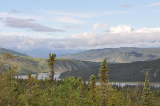
Finger Mountain, the second major point of interest is not much of a mountain at all, little more
than a hill to the normal eye, but it is an anomaly to the region; formed from lava outcroppings
300 million years ago when rock pushed though the earths crust and changed the landscape forever -
it is a unique feature of the artic tundra and stands out, "like a sore - FINGER!"