Wednesday, June 30, 2010

Kanab - With Help from Friends

After leaving Grand Canyon, it was over an hour drive to connect to highway 89 at Cameron and the location for the Junction Campground.

In retrospect it would have been wise to check out the campground to at least find if they had tent sites available; but, there was still daylight and I remembered talking with fellow bikers who had mentioned that they were going to Tuba City.  It wasn't as if they had talked in glowing terms about Tuba City, but nonetheless, I felt almost compelled to go there - it was a mistake.  The Junction Campground had been right on the highway, but Tuba City was twelve miles east of highway 89 (why must I make things so difficult?)

Actually, the campground at Tuba City (part of Quality Inn) was clean, neat and reasonably priced.  It had one minor problem though, Tuba City is part of the Navajo Nation and thus the sale if alcohol is prohibited - I just wanted a beer, but that was not to be.

Page, Arizona was my next stop; located just to the south of the Utah border and the site of the beautiful Glen Canyon Dam.  Actually, the city of Page was built in 1957 to house workers building the Glen Canyon Dam.

Today is Page is a progressive looking community without any of the remnants of a bygone past to contend with that haunt most cities.  With only the present, the future and their short history to deal, they are the envy of many a community.  The monstrous Lake Powell (the second largest man made lake on the United States - after Lake Mead) created by the dam - the Glen Canyon National Recreation Area is a recreational Mecca for American vacationers.  

My plan for the day was to proceed north into Utah to Bryce Canyon National Park.  It was only a four hour, 234 mile ride (according to Map Quest) that should have been no problem - if only I had kept gas in the tank!

Just to the West of Page the highway crosses into Utah where Big Water is barely a blurb before beginning the 74 mile trek to Kanab, Utah.  Obviously, with all of my past experiences I should have made sure that there was plenty of gas in the tank, but for whatever reason, I failed to so.  Fifteen miles east of Kanab my Harley droned to a stop.
There was little doubt as to the problem - I had been there before.

Highway 89, as the main road north from Flagstaff (and also the most direct route to Bryce Canyon), it is the favorite of RVer's and biker's alike - surely, someone would come to my aid.

However, everyone has there own agenda and I couldn't fault them for not stopping; but a lone biker on the side of the road, is seldom passed by other riders and I wasn't either.

A couple of European's, riding rented Honda's motorcycles out of Florida, stopped to offer their assistance and even offered to siphon gas from one of their tanks - but, no one had a hose.

One of them suggested I flag down a car.  Left with few alternatives, I reluctantly agreed.

At first I tried attracting a truck pulling a boat, which would most likely have available gas, but to no avail.

Impatient, I tried to flag down anyone else who would stop.

I remembered how in my youth I had sometimes hitch-hiked and always met interesting people; it was like reliving the past when a man in his 40's stopped to assist.  He didn't have any gas or a hose (anyway, the bikers had since departed), but offered to take me to Kanab.  He told me that he had traveled these roads years before, when as a college student he (twice) "walked" from Provo to Flagstaff (a "short" month long hike).

At the Kanab Phillips 66 station, were he dropped me off, I secured a gallon of gas and trudged, gas can in hand, back to highway; feeling quite foolish (as well I should have).

I was comforted by the feeling that, "this hopeless looking sole" standing along side the highway in swelter heat would certainly stir someone's compassion; but most of the traffic was going north or turned at the gas station short of my location.

Even so, less than fifteen passed, before I was picked up by a young girl returning home from work.

Donna had her own set of problems, but she none the less was kind enough to concern herself with mine.

Her "middle-aged" pickup truck had vice-grips locked in two places around the steering column (one as a pseudo gear shift and the other serving some unknown function).  She advised me that the air conditioner didn't work and when I asked for her permission to roll down the window, she replied - "that doesn't work either!"  And she stopped to help me!  

Donna said that she worked at the grocery store in town and lived just five miles east of Kanab.  My Harley still waited for my return, fifteen miles to the east.  None the less, Donna drove without hesitation the back to my Harley, and at first refused to accept my paltry offer of $10.  She relented when I advised her that, "that will at least pay for your gas."  Bless you Donna.  

Tuesday, June 29, 2010

The Grand Canyon

When I left Flagstaff the Hardy Fire was still raging out of control, and its cause was unknown.  Since that time, however, they have arrested a 54 year old California man for accidentally starting the fire.  The Shultz Fire was (and is) still burning, and is now listed as 75% contained.

The ride out Flagstaff (northwest on highway 180) was a cool and comfortable motorcycle ride with surprisingly little traffic.  This land was part of the Kaibab National Forest and had apparent, restricted development; in any case there were no towns, in the 52 mile stretch before the highway connects to highway 64 and proceeds due north, and little to no housing.

My direction was of course Grand Canyon.  This would be my second trip to Grand Canyon; on the first, perhaps ten years ago (the years all seem to run together now), I walked the 9 miles down the Bridal Vail Falls trail, to the bottom of the canyon and across the Colorado River to Phantom Ranch.

The Phantom Ranch was built in 1922 by the Fred Harvey Company concessionaires, to service hikers.  It was no problem to make the trip back then (how many ever years ago), but today it may require as much as a 13 month advance reservation.

It was (and I'm sure, remains even today) a long hot hike with spectacular vistas along the way which provided another photo opportunity with each "hair-pin" turn of the wide trail.  I'm glad I made the trip and would do again without hesitation - but, not this time!

Upon reaching the Grand Canyon Visitor's Center I stopped for guidance and directions.  Although, my route was already pretty much predetermined by the only highway that follows along the south rim - highway 64.
            
It was a great ride that provided many photo opportunities for the "well prepared" photographer.  Unfortunately, I was not that "well prepared" photographer - my camera battery ran dead at the second vista opportunity.

Actually, it was not all my fault (I told myself); my camera indicated almost 1/4 of battery life left, but my camera disagreed and would not function.  In reality, I knew that it was a careless mistake to not have recharged the battery on the previous night (strike one!)

Nonetheless, I had no other choice but to return back to the visitor's center and find somewhere to give the battery the twenty minute battery charge that I believed would allow me to take all of the photos that I would need.

At the Visitors Center Bookstore, I found the likely plug-in location - surely, Grand Canyon National Park wouldn't mind my "borrowing" a little electricity!  In the entry there way foyer, between the double doors, there was an unused plug-in just waiting for me.

I thought about going up to the counter and asking for permission, or even offering to pay a reasonable fee the use of the plug-in; but then, what if they refused - then I would be TOTALLY SCREWED!

No, it would be better to take the clandestine route.


As I plugged my battery charger and surreptitiously (how surreptitious can one be in the bookstore entry way) laid it down; I was heartened by a young lady passing by, who said with an approving smile "Hey, you do what you've got to do."  Thank you, young lady!  As a side light - I must add - I donated $5.00 to box in the lobby in gratitude (see, I'm not, THAT CHEAP!)

After charging the battery the rest was easy, just point, shoot and enjoy the beauty of one of the seven natural wonders of the world.

Monday, June 28, 2010

Flagstaff and the Lowell Observatory


The ride from Winslow to Flagstaff was less than two hours on I-40, and as I approached the city, the grade and elevation increased and the air cooled even with the rising noon day sun.  

I am sure that some time, in my distant past, I drove through Flagstaff, but it was such a memorable occasion (and just a drive through) that I don't, now, recall ever having been there; and so, I was quite impressed with my first stay in Flagstaff.

Flagstaff is smaller than I had previously thought (population 52,894 as of the 2000 census), or at least it has that small town feel, which I like.  Like many of the places I've been, Flagstaff made me feel as if it would be a great place to live -in the SUMMER!  

I'm quite certain that I couldn't deal with the often repeated statement on the weather channel - "The cold spot in the nation - Flagstaff, Arizona."

Other than just seeing the city itself, the main place that I wanted to visit in Flagstaff was the Lowell Observatory.

The Lowell Observatory is located less than two miles from downtown Flagstaff at the end of a winding road with a great overlook of the surrounding countryside.


On this day the "great overlook" hosted a surprise - the Flagstaff fire (labeled as the "Hardy Fire") had just begun and was ragging out of control.  Five days later it was 95-100% contained, but a new fire started the next day (dubbed the "Schultz Fire") and after 8 days, it is still only 55% contained.

Forest fire aside, the Lowell Observatory was a great experience.  The observatory was built in 1898 by Percival Lowell, quite simply, because he had the money and the interest to do the same.

The Lowell Observatory is best known for its discovery of the Planet Pluto (which has now officially been demoted to class of a "dwarf" planet).  There are now, officially eight planets in our solar system.  

The observatory no longer operates in an official capacity for astronomical observations, but rather a serves as an educational "tool" to educate the public about the wonders of the universe (all astronomical observations are now conducted at Anderson Mesa, 19 km southeast of Lowell Observatory).   

They offer tours throughout the day that serve well to prepare one for the real "headliner," which might be called - an evening with the stars!

Three hours later, after having left the observatory to grab a bite to eat and burn some time, I returned in anxious anticipation of an opportunity to view the stars through the 24 inch x 32 foot long (between the refractors) Clark telescope.

As I had expected there was a long line awaiting the opportunity to look through the Clark Telescope.  After waiting for the allotted time I was somewhat surprised by what I saw.  Most likely it was the build-up from looking at the pictures from inside the visitor's center; but, although I'm glad to have had the opportunity, it was less than I expected.  I went away thinking that I have been more impressed by the "Milky Way" on a good star filled night.

In the end, what did impress me, were the two smaller portable telescopes that were honed in on: the craters of the moon and the planet Saturn, respectively. 

Saturday, June 26, 2010

Winslow, Arizona and Meteor Crater

Feeling eager to get out New Mexico (had a great time, but had to go!), I departed to the west out of Farmington intending to turn south in Shiprock to pick-up I-40 towards Flagstaff, with one stop in-between at Meteor Crater.  There was a shorter and more direct route to Flagstaff, but going that way I would miss Meteor Crater; not an option.

South of Shiprock the wind got "fierce" (a pattern that would continue all the way to Flagstaff); but after thousands of miles I've become accustomed to such minor inconsistencies, just as long as it stays a "minor" inconsistency.

After checking the map for a stopping point near Meteor Crater, I found the most likely spot to be Winslow, Arizona; with its close proximity to the crater, it seemed reasonable to expect that they would have a campground.

Winslow, Arizona - something about the name sounded familiar, but I couldn't make the connection at first.  Shortly thereafter, I found myself hearing the words (in my head) to a song that fit with - "...in Winslow, Arizona - and struggling to the recall the words.

Then, it hit me - "...in Winslow, Arizona, such a fine place to be;" but I still couldn't put my "hand" on the first stanza.  It would be two days later before I would pass - "standing on the corner" park, and solve the mystery to the first stanza - "Standing on the corner in Winslow, Arizona, such a fine place to be."

For a time, the song and the fact Winslow was (and is - still today) a stopping point on "Old Route 66," which put Winslow, Arizona on the map as a popular stopping point.

That time has past, however, (as is testified by the number run-down and closed motels which now permeate the city) and Winslow would do well to seek other opportunities.

Fortunately, their are new hotels and some signs of new life, but to me "the city father's" would do well to pay less attention to the past and try "play-up" what would seem to be there best drawing-card (the most obvious of the other opportunities that exist) - Winslow's close proximity to Meteor Crater.

Meteor Crater National Landmark is a short 16 miles to the west of Winslow, just south of I-40.  It is so close to the highway (just 6 miles) that it seems surprising that anyone traveling would pass it up; but, I'm sure that they do, and it's their loss!

The crater is a magnificent sight - 550 feet deep and 3/4 of a mile across.  It was created 50,000 years ago by a meteor that is said to have been the size of football field (small indeed, considering the size of the hole that it left - originally 700 feet deep).

In 1903 Daniel Barringer was the first to prove that the crater was formed by meteor impact rather volcanic eruption as previously believed.  Barringer spent years in researching the crater which is privately owned by the Barringer Family, as a non-profit institution.  Since the crater is privately owned, it is not eligible for National Monument status and is instead designated as a National Landmark.

Also, (probably due to its private ownership) it is surprisingly expensive ($15 per adult, including the museum) when compared to the national parks.

Even so, when all things are considered, it is still a bargain and well worth the stop.

As magnificent as it is, I spent little more than two hours at the site and almost felt guilty for leaving after such a short time.  It may have been possible to walk the bottom of the crater (I didn't ask, but also, saw no one making such a trek).  After touring the museum, talking to the rangers, and taking photographs I felt that it was best to take advantage of the time available, return to Winslow, and prepare to get a decent start for Flagstaff in the morning.

Thursday, June 24, 2010

Back to New Mexico

From the Canyon of the Ancients at Hovenweep, I rode back into New Mexico along Highway 149 through Cortez to find a campground.  My first stop was at Shiprock; but forget it, there are no campgrounds in Shiprock - only that big volcanic rock (in geologic terms fractured volcanic breccia called "minette") from which the town takes its name.  The next closest town was Farmington, 23 miles to the east; and although, it was not the direction of choice, it was getting late and surely Farmington would have a campground.

BINGO!  It was well past 9:00, but Mom & Pop's RV came to the rescue - and only $7.50 a night for a campsite.

Besides having great a price, Pop (as he prefers to be called) is a congenial and helpful host who offers a guide places visit in the Farmington Area.  His top choice was The Bolack Museum of Fish and Wildlife.


Pop offered that, "Tom Bolack has a fantastic collection of wild animals that he collected over many years of big game hunting and fishing experiences - and it's FREE!"

Although, I have never hunted (except with a camera in Africa), the museum was less than a mile from "Mom and Pop's RV," so why not check it out.


For me, it was a, love-hate relationship; while admired all of the beautiful mounts, I couldn't help but abhor seeing all these magnificent beasts of the wild killed for the "sport" of it - only to support one mans vanity.

His collection is little short of fantastic; and even included the skeletal head and tusks of a wholly mammoth.  Among his 2500 mounts it seemed as if he had killed all most every conceivable creature known to man - elephant, rhinoceros, lions, leopards, tigers, zebras, giraffe, wildebeest, rare black leopards (there were two) and bear of all kinds  including: grizzly, black, brown, polar and Kodiak - to name but a few.


Tom Bolack was (he died in 1998) without a doubt a great conservationist as most hunters are; but it is so much more difficult (and more sportsman like) to take a great photograph than it is to make a great shot - and nothing and no one suffers as result.


I realize that this is a very controversial issue and that many of you many of you may be avid hunters yourselves; but I will continue (as I always have) to support your right hunt, and only hope that in return you will respect my right to have a differing opinion.

Upon returning to the campground, I had to stop to admire Pop's model train (Extraordinaire), model boat and his collection of hundreds of cast lead alloy miniature's he has cast and meticulously hand painted.   He (quite literally) had a hand, in almost everything in his collection.


The mention of lead alloy "raised my eyebrows;" and so, I asked him about the commonly held fear of lead poisoning.  His comment was - "I could swallow it and it would just flush out the other end."  Fired up now, he continued (to the effect) that, "the EPA has everyone so buffaloed with all there gibberish - I wish they would just disband the whole organization."  


Although, I often disagree with some of the EPA/FDA positions myself, but I strongly support their missions.  Like many others, I question how "in-bed" they are with the drug  and the major food processing companies (especially in light of the fact that many former congressmen and women end up working as paid lobbyists).

Pop's model train is not working, at this time, and perhaps it will never run again.  It is uncovered, which is surprising in light of his obvious extensive amount of time and money invested in its development.  As Pops' so apply put it, "If I had known that it was going to get this out of hand, I would have put a roof over it!"

Before leaving New Mexico, I had one more mission - the ruins of Chaco Canyon.  The Chaco Canyon National Monument was just a short 75 miles south of Farmington - too close to just pass it up?

Getting to Chaco, however, was not the easy task that it was assumed to be.  It was an easy ride for the first 59 miles; but then, the road turned to a "washboard" composition of gravel and sand.  I continued on, determined to make it through the 14 miles of sand and gravel that lay ahead.

Did you ever ride a motorcycle in sand?  "It ain't fun."  After about three miles, traveling at about ten miles an hour and dodging the sand as best possible; I abandon my pursuit, only after nearly dumping my Harley twice.

When I stopped the tire was buried in almost three inches of sand; the question was - "would the road continue to get sandier (as it appeared to be doing) or would the sand just amazingly disappear?"  The latter prospect seemed unlikely, and so, I pushed the bike out of the sand and parked it to the side of the road (well, kind of - sort of to the side of the road) and stuck out my thumb.

About 5-10 minutes passed, as did four or five vehicles, seemingly unconcerned for my quagmire (I forgave them; after all, how were they to know that I was not - "Jack-the-Ripper" and the camera I "wielded" was not a bludgeon?).

Fortunately, my day was saved a great American - a great Native American.

Theresa, from Berkeley, California, was on vacation herself and exploring her heritage along the way.

After helping to setting up her tent in the Chaco Canyon campground, we share the day together, enjoying each others companionship and "treasures" of Chaco Canyon.

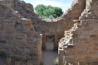
Every site of Indian ruins is unique, and the Chaco Canyon Ruins are no exception.  It features one of the largest kivas in the Ancestral Pueblo world and one of the most grandiose of pueblo ruins the Pueblo Bonito; yet, the mystery remains of why they would chose such a beautiful, but inhospitable place - A place without a reliable water supply and forbidding heat to contend with.

Later that day she drove me back the ten miles to where my Harley (fortunately) was still parked.  I thanked her, and secretly "kicked" myself for depending too heavily on my credit card; with only $3.00 in cash I could even offer to pay her for her trouble (and gas).  She likely would not have accepted it anyway, but would have liked to have been able to afford her that option.  Thanks again, Theresa, for everything.

Saturday, June 19, 2010

The Mesa Verde and Hovenweep Ruins


From Durango it was only a short ride to the ruins of the Mesa Verde National Monument.
It would be my second visit to Mesa Verde; the first was a ski trip to Telluride with my daughter (Jamie) over the millennium New Year celebration of 2000.  Jamie stayed on the mountain and snowboarded for the day while Dad trekked off to the ruins.

The winter, of course, had provided entirely different view than what I anticipated seeing now; although, that winter time experience had only traces of snow and almost no other visitors.  In fact, most of the site was closed to visitors during the off-season and my time at the ruins was, therefore, limited to only a matter of hours at Spruce Tree House.

With summer now in full swing, the campground and RV Park were busy, but less crowded than expected (with the sour economy American's are still not vacationing as actively they once had).

One word of advice for bikers and anyone requiring premium gasoline, it is a sparse commodity in and around the area east of Mesa Verde and not available at all in the park itself.  Fortunately, premium gas is available in Cortez, ten miles west of the entry to Mesa Verde.  

The approach to Mesa Verde is spectacular in itself, with winding roads yielding amazing vistas.  Mesa Verde is not a single ruin, but a complex of ruins separated by miles a paved roadway.  In fact, there are said to be more than 600 sites, ranging from a simple pit habitation to the Cliff Palace - the largest cliff dwelling in North America.

For me, the many fantastic vistas that the sites provided were worth the trip in of itself.  Had there been no ruins at all, I would not have wanted to miss the ride.

But, of course, there are ruins, and they are truly incredible!

The larger sites are built within naturally occurring alcoves which provided the back walls and (in some cases) the ceilings from which the pueblos are built.

The first stop is the visitors center, and don't pass it up; many of the sites are ranger guided tours requiring scheduled tickets.  The tickets are not expensive and guided tours are an interesting and fun time.

All of the sites require a fair amount of walking (with the exception of the Far View Site) and none of sites are handicap accessible.  In fact, visiting Mesa Verde is a moderately strenuous undertaking, and often includes steps and ladders to climb, as well as, low and narrow passageways - but, it's all worth it!

There hiking trails (for those of you that are so inclined) and even though I am not an avid hiker, when I saw a sign pointing out the trail to the pictographs, it was too much to resist.

Unbeknownst to me, however, the trail was three miles long; up-down and over rocks and numerous other appending obstacles.  Had I read the brochure before hand, I never would have taken the trail and would have missed a great experience.  The pictographs were "neat," but the views that were provided by the trail were very special indeed.

I left Mesa Verde wondering if it deserved of yet another day, and knowing that the answer was, "Of course it did, - perhaps even Extra DAYS!"  It is a very special place!

Even so, it was time to leave; in fact, time now seemed to be my enemy, barely more than a week ago I was urging myself to slow down, but now it seemed as though I had succeeded all to well in that effort and now the pressure was on to - SPEED UP!

However, there are obstacles in my path, I need take some time off from my travels to catch-up on my blog and attend to pressing personal matters (bills etc.)  If I push on to Hovenweep, will another day of experiences, requiring more blogging, only worsen matters?  Perhaps, but so be it.

Hovenweep is a somewhat isolated location about 40 miles north of Cortez and noted for the fact that, the ruins are very much they were when they were first discovered in the mid-1800's.

The most distinctive features of Hovenweep are the round and square towers the true nature of which is a matter of some conjecture, but they are not believed to have been used as kivas or ceremonial centers.

While the Hovenweep site extends for many miles, the location I visited (north of Cortez) provides an easy to moderately difficult, self guided walk of about 2 miles over well marked trails.

Again, for me, a lot of the enjoyment of visiting the pueblo ruins (and Hovenweep was no exception) is the setting within the canyon walls where the ruins lie.  It seems incredible that, though by most accounts, there is little evidence of warfare (among the puebloans} that would have encouraged such isolation; they nonetheless, chose to build in some of the most difficult settings that one can conceive.    

Thursday, June 17, 2010

The Four Corners - Land of the First Americans

It was time to move again and I actually had a plan - westward toward Farmington (in the Four Corners region of New Mexico, Colorado, Utah and Arizona) to explore the Aztec ruins as was the original intent before the Cumbres & Toltec Railroad intervened.  From there the plan was head north to Durango and Cortez, Colorado and on to the Mesa Verde and Hovenweep Ruins, before returning back to New Mexico to find a campground around Farmington.

The Puebloan's, of course, knew no borders and Hovenweep itself extends for miles into and around Blanding, Utah which is (because it is in Utah and not Colorado) considered to be a separate ruin.  I knew that this area would be less explored and might therefore offer more interest; but then, it was likely to be gravel roads and much less motorcycle friendly and was, therefore, left off the planned agenda.

Even by choosing the Four Corners region and drawing "a line in the sand," I still crossed the line.

Chaco Culture National Historical Park is less than 80 miles south of Farmington, and too much of allure to resist.

There are literally hundreds of archaeological ruins left by the first Americans; a large number of which blanket the southwest.  With so many ruins available to see throughout New Mexico, Colorado and Arizona (in particular) and to a lesser extent Utah, it was once again difficult to choose a route of travel to see as much as possible without - making a career of it!  The Chaco Culture would be just one last stop before turning west for Arizona.

In the of course of asking questions about The Aztec Ruins, someone mentioned that, "There was not that much to see at the Aztec Ruins National Monument;" and so, when at last I found myself standing within the compound of the ruins gazing over hundreds (450) of pueblo rooms, I was awe struck!  Not much to see?  What had he been looking at?

What we see today is not as it was in the period of its occupation.  The rooms were two and even three stories high in places, but how far did the multi-stories extend (no one knows for sure).  Then too, the original walls were covered smooth with a stucco-like parging and it's believed that they once walked across the roofs of the Kivas.  Unlike the Maya and (presumably) the Aztecs of Mexico they used a mortar like base to bond the stone work together.

Round Kiva's or ceremonial centers abound throughout the complex the largest of which is a Kiva reconstructed by early archaeologist working at the site.

This huge Kiva perhaps create more questions than it answers; its diametric size is without question but height of its walls and the number of stories of the are questions, the answers to which are forever lost in time.  

As impressive as the ruins are there is an entire set of east ruins (said to be approximately equal in size, remain yet to be excavated and are therefore closed to visitors.

Of course, the site is not an Aztec site at all.  It was given that unfortunate misnomer by the great South American explorer Alexander Von Humboldt, who mistook it to be related to its distant neighbors to the south.  Given the time frame and how little was then known about early American ruins, his error is easy to understand.

It was a relatively short ride from Aztec to Durango; and when I rode into the town, I peered through the trees from highway that overlooks the city below.  My first thought, given my brief glances, was that I was overlooking an open pit mine of some sort (I still don't know where that thought was coming from); nonetheless, however wrong, it was my first impression from my brief, but inspiring overlook (see the sloping roadway).

Durango is a college town with a very collegiate (or even Yuppie) atmosphere.  In a strange way it had, for me, the look and feel of mini (very mini) Austin, Texas.    

My stay in Durango, which only intended to be an overnight at the nearest campground, did not go well.

The site of the Durango & Silverton Narrow Gauge Railroad (ala, the Cumbres & Toltec Train - Chama, New Mexico) Durango is a popular tourist destination; and as such, an expensive place to stay.

Surprisingly, given the tourism, I had a hard time even finding a campground and when I did it was (not surprisingly) a quite expensive $28 a night for just a primitive tent site.

Before leaving Durango, I decided it would be good to replace one of my aging Harley T-shirts with a new Durango Harley Davidson T-shirt.

While there, I made another decision to have my Harley checked out.  A day and a half later, and after having relieved myself of $900 dollars, I left Durango with "fond memories;" I knew that my tires were getting bad, but the brakes (which were in worse shape than the tires) surprised me.

The truly unfortunate thing about my brief visit to the Durango Harley Davidson, was that, the one thing that I wanted have checked out, did not get checked.  They told me that the repair parts (if needed) were on backorder, and as a result they recommended not doing the check out.          

Monday, June 14, 2010

Chama and the Cumbres & Toltec Train

The ride to Chama was unchallenging (for which I'm truly grateful), but it was yet another beautiful ride.  The highway reached an elevation of over 10,000 feet, with patches of snow still visible before descending back down into what is called New Mexico's - High Country.

At this point highway 64 joined highway 80 and turned north (the sign that Chama only a few miles ahead).  With my gas gauge still not working I was more than a little dismayed when first visible gas station was closed.  It was only a little after 7:00 PM, but I was told there wouldn't be any gas before Chama, now a mere 9 miles away.

It was almost a certainty that there was more than enough gas in the tank, but since I had failed to write down the odometer reading at the last fill-up, my exact predicament was not so certain.  What difference would it have made anyway; it would only given the possible assurance that - Yep, you aren't going to make it!

Luckily, the gas held out with a half gallon to spare!

Finding a camp site in Chama was, also, not a problem.  The Little Creel Resort was an excellent choice with all the amenities (including riverbank camp sites), great prices and Rob & Mary Anderson, who manage the site, were great hosts.

Chama to my surprise is a bit a tourist Mecca - the site of the Cumbres & Toltec Scenic Railroad.

This was yet another unexpected, but much welcome surprise.  As soon as I heard that a narrow gauge steam locomotive operated out of Chama, my stay in Chama was planned.

The Cumbres & Toltec Scenic Railroad is the remnant of the San Juan extension of the Denver & Rio Grande Railway.  The line was first developed in 1880 to in order to service the booming mining resources of southwestern Colorado.

It connects Chama, New Mexico with Antonito, Colorado and so doing, winds its way over the 10,015 foot Cumbres Pass and through the spectacular Toltec Gorge.

The ride begins out of Chama at 10:00 in the morning, but it is best to arrive early, walk around the rail yard (and even climb aboard), visit with the dedicated staff of largely volunteer railroad aficionados and explore one of the best preserved railroad museums in the United States.

The train ride offers three different classes of rail travel: the parlor class, tourist class and coach class.

My choice was the coach class, not only because it was the most affordable, but it offered the most freedom movement to the refreshments coach and the "cattle car" (the open air flat bed, which is a "must").

The original steam engine locomotive "barrels" down the 36 inch narrow gauge track at about 15-20 miles an hour and is, therefore, a full day experience.

Although, the rail cars are not original, you wouldn't no the difference - they have been replicated to exacting specifications on the original railcar platforms.

The engineers and conductors are all outfitted in 1890's attire and the entire experience is a just great day of fun; complete with a luncheon stop at Osier before continuing on to the destination of Antonito, Colorado.

From Antonito the day is concluded with a drive by motor coach back to Chama (an enjoyable scenic ride in itself).

Saturday, June 12, 2010

Places Along the Way

My destination was the Aztec Ruins National Monument northwest of Taos near the Four Corners region of New Mexico, Colorado, Utah and Arizona; to far to go in one day, given my normal (got to fix this) late start.

Not allowing extra travel time is not wise thing, especially given the areas wide open spaces between towns and the infrequent availability of gas.  It was a pretty safe bet that there would a campground at the Aztec ruins or in the city of Aztec, but in between - Who knows?

Therefore, it seemed best to just "wing it" and hope to a find a campground somewhere along the way; if worse came to worse, as one goodhearted passerby put it, "Your in the country - you can sleep anywhere!"

Going north out of Taos on highway 64 (the route of choice to take me within a few miles of the Aztec Ruins National Monument), I was thinking that the scenery, was nothing special for New Mexico, when seemingly out of nowhere there was this magnificent gorge - the Grand Canyon Gorge of New Mexico.  This gorge, at the bottom of which flows the Rio Grande, was a total unexpected surprise.  My map showed the Rio Grande crossing highway 64, but made no mention of the gorge itself and it's spectacular!

After taking numerous photographs I got back on my Harley and traveled less than a mile before coming to an unusual looking set of buildings with a sign in front reading, "Earthship Biotecture & Biodiesel - Visitors Center."  My first thought was, "Why in the H---, would anyone build here - in the middle of No Where!"  It was a question for which I never got a good answer; perhaps it was the water - but at the bottom of a 500 foot gorge?

Yet another surprise, twice in one day, first the Grand Canyon Gorge and then Earthship.

Unfortunately, once again, I was too late.  The sign on the door read "Tours - $5 per person, (Hours 8:00 AM to 4:30 PM)".  It was 4:40 PM!

Having heard or read about Earthship somewhere in my past, and having been a "pseudo" builder and building trade's teacher, I really wanted explore the workings of Earthship; but, it was not to be.

Added to that, was the fact, that Earthship was miles from anywhere and I knew that returning on another day was, also, not an option.

Even so, there was no harm in walking around the house and taking photographs.

The design is kind of exotic or other worldly.  Lacking the square corners of a typical house, it appears (as it no doubt was) to have been molded and shaped my hand, as if, one was playing with modeling clay.
Too my surprise, architecturally, it seemed to display a Moorish influence.

An added surprise was that (given their eco-friendly environmental consciousness) the place seemed to be inexcusably trashy; but then - don't look in my garage!

I knew that the concept of Earthship was to use of
waste materials such as bottles and tires as "fill material," which is combined with inexpensive straw and compacted mother earth, as the basic building materials.  

While walking around the outside, other visitors pulled up to site only to be equally dismayed at having missed an opportunity to take the tour of the inside.  One of the assumed visitors was an attractive "40-ish" lady, who introduced herself as Christine and explained that she was from Hawaii and had come to "Earthship" to learn about its inner workings; especially (not surprisingly given her Hawaii origin) with regard to Earthships water recycling system.

Christine further explained, to my surprise, that there were approximately 40 Earthship structures in the surrounding area (I later discovered that they have been built in many parts of the world).  They are all "nearly" totally self-sufficient, producing there own energy and being so well insulated that they were comfortable all year around.

Unfortunately, she had only been there for two days; and was hence, as she explained, "not an authority on Earthship.

Without any stops (an unlikely event) the nearest town along highway 64 was Chama; at least a two hour drive and by that time gas would be an issue - there was no time for further delays!

Wednesday, June 9, 2010

New Mexico - The Land of Enchantment

Now comes the hard part; so much to see, so many places to go - where do I start?

Mapping out a route is one of the really difficult things about traveling around to country and just trying to discover North America.  I'm already having misqivings about not having gone to the area of the White Sands National Monument, and am now trying to see how I can somehow fit it back into my itinerary without adding miles (and days) of extra travel time.

From Roswell, I rode north on highway 285 intending to seek out a few of the numerous pueblo ruins (and any other points of interest along the way).  For sure my quest to see as much as possible will take me into the four corners region of Colorado before returning back to New Mexico and west towards Flagstaff, Arizona.

New Mexico is such a fabulous state; it may be America's best kept secret.  Simply put - I love New Mexico!  The scenery is awe inspiring, and even the (perhaps all too common) abandon and down trodden home, failed businesses and all but failing villages are intriguing photo opportunities.

The sun can be blistering hot, but the strange thing about riding a motorcycle in New Mexico is that, despite the heat you feel almost no discomfort, just don't stop riding (as soon as you stop the heat hits you like a sledge hammer) - and make sure to use sunscreen.

One, point of interest, that I intended to visit was the grave site of Billy the Kid at Fort Sumner; but I missed my intended turnoff and went approximately 60 miles to the west (note to self: check the map).

Not to be defeated, I turned back east rode across the baron landscape, questioning why it was so important to see the tombstone of a murdering outlaw; but knowing the answer - we love our folk heroes.

It was after 5:00 by the time I arrived in Fort Sumner and the Billy the Kid Museum was closed (thanks to my failed map reading), but fortunately not the grave site.

The gravestone is surrounded by a fenced barrier to protect it from would be thieves (the headstone has been stolen twice), and marks the graves of Billy the Kid and two of his outlaw friends who share the grave site identified with the one word epitaph - "Pals".

After photographing the headstone, having no desire to spend the night in Fort Sumner I rode north to my intended campsite at Santa Rosa; a historical stopping point on Old Route 66.

The next morning I was late getting out of Santa Rosa, but succeeded mapping out a new direction - next stop Taos, New Mexico.

Taos had not been one of my intended stop, but as a once avid skier and sometimes snowboarder, once I saw the tiny dot on the map (and how close it was to my general route of travel - "Which didn't exist") there was not any way to avoid going to Taos.

Along the way to Taos, my scenic ride passed through the town of Mora, the Cleveland Roller Mill.

Mora is a small village of less than 4,000 which some has that elusive unexplained magic that makes one feel at home almost immediately.  It is not as though I would want to homestead there, but it would have (perhaps) been fun to stay for a few days; but it will have to wait for another day and another time.

The Cleveland Roller Mill is a restored roller mill which operated into the 1940's and is still operational for exhibition purposes.  Today the mill includes a museum, but once again I arrived after hours.    

I was quite surprised to find that rather than Taos being a old mining town (as many of the ski areas are) turned ski area; Taos is a very resort style, "up-beat" and progressive community of over 30,000 residents.

It was impressive with the way that the city father's (and rigid zoning regulations I'm sure) have preserved the very New Mexico style adobe architecture and carried the theme throughout the community.

Even so, (for me) there seemed to be something missing, it had too much of a "Disneyland Atmosphere" to suit my taste - and I don't know quite why!  

I feel guilt and that my assessment is too harsh and unfair given my brief time there; after all Taos is supposed to be "Hot Town USA" - perhaps, the ski season would put it a better light!